You are here: Home > Network List > TA - USArray Transportable Network (new EarthScope stations) Stations List
> Station KMSC Kings Mountain, Blacksburg, SC, USA > Earthquake Result Viewer
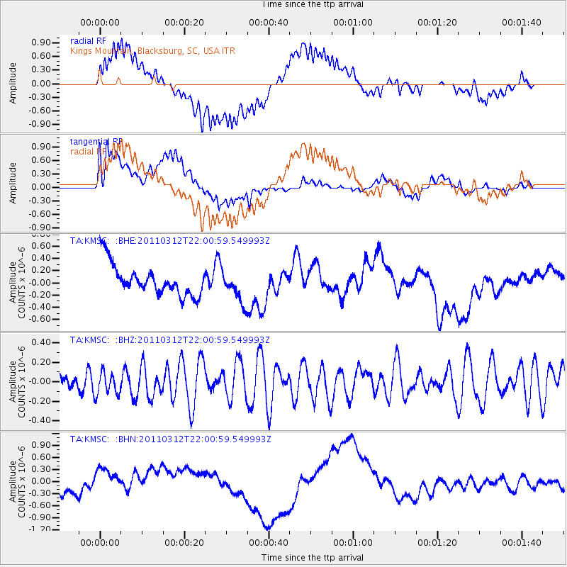
KMSC Kings Mountain, Blacksburg, SC, USA - Earthquake Result Viewer
*The percent match for this event was below the threshold and hence no stack was calculated.
| Earthquake location: |
Near East Coast Of Honshu, Japan |
| Earthquake latitude/longitude: |
39.6/142.6 |
| Earthquake time(UTC): |
2011/03/12 (071) 21:48:09 GMT |
| Earthquake Depth: |
26 km |
| Earthquake Magnitude: |
5.5 MB, 5.3 MS, 5.6 MW |
| Earthquake Catalog/Contributor: |
WHDF/NEIC |
|
| Network: |
TA USArray Transportable Network (new EarthScope stations) |
| Station: |
KMSC Kings Mountain, Blacksburg, SC, USA |
| Lat/Lon: |
35.14 N/81.33 W |
| Elevation: |
240 m |
|
| Distance: |
95.3 deg |
| Az: |
34.801 deg |
| Baz: |
327.456 deg |
| Ray Param: |
$rayparam |
*The percent match for this event was below the threshold and hence was not used in the summary stack. |
|
| Radial Match: |
45.72591 % |
| Radial Bump: |
400 |
| Transverse Match: |
53.48776 % |
| Transverse Bump: |
400 |
| SOD ConfigId: |
356183 |
| Insert Time: |
2011-08-20 06:39:00.742 +0000 |
| GWidth: |
2.5 |
| Max Bumps: |
400 |
| Tol: |
0.001 |
|
Signal To Noise
| Channel | StoN | STA | LTA |
| TA:KMSC: :BHZ:20110312T22:00:59.549993Z | 1.0215453 | 1.1168252E-7 | 1.0932703E-7 |
| TA:KMSC: :BHN:20110312T22:00:59.549993Z | 1.012037 | 4.5398082E-7 | 4.485812E-7 |
| TA:KMSC: :BHE:20110312T22:00:59.549993Z | 1.0703242 | 2.6833328E-7 | 2.5070278E-7 |
| Arrivals |
| Ps | |
| PpPs | |
| PsPs/PpSs | |


