You are here: Home > Network List > TA - USArray Transportable Network (new EarthScope stations) Stations List
> Station MSTX Muleshoe, TX, USA > Earthquake Result Viewer
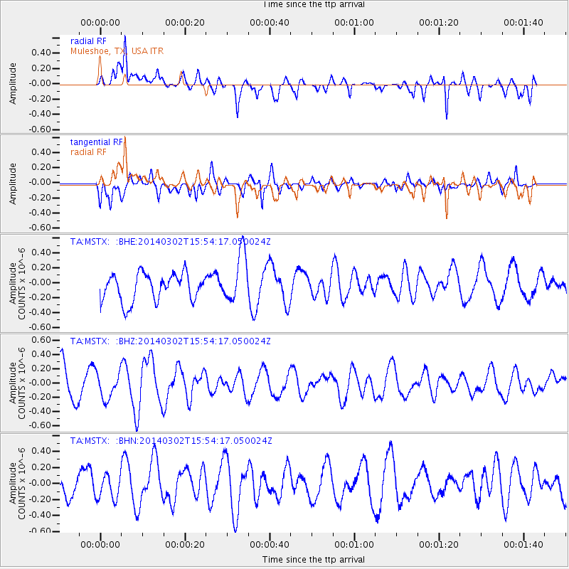
MSTX Muleshoe, TX, USA - Earthquake Result Viewer
*The percent match for this event was below the threshold and hence no stack was calculated.
| Earthquake location: |
Tonga Islands |
| Earthquake latitude/longitude: |
-21.4/-174.0 |
| Earthquake time(UTC): |
2014/03/02 (061) 15:42:03 GMT |
| Earthquake Depth: |
25 km |
| Earthquake Magnitude: |
5.2 MW |
| Earthquake Catalog/Contributor: |
ISC/ISC |
|
| Network: |
TA USArray Transportable Network (new EarthScope stations) |
| Station: |
MSTX Muleshoe, TX, USA |
| Lat/Lon: |
33.97 N/102.77 W |
| Elevation: |
1167 m |
|
| Distance: |
87.3 deg |
| Az: |
51.988 deg |
| Baz: |
242.045 deg |
| Ray Param: |
$rayparam |
*The percent match for this event was below the threshold and hence was not used in the summary stack. |
|
| Radial Match: |
76.97707 % |
| Radial Bump: |
400 |
| Transverse Match: |
49.187683 % |
| Transverse Bump: |
400 |
| SOD ConfigId: |
3390531 |
| Insert Time: |
2019-04-10 11:37:47.954 +0000 |
| GWidth: |
2.5 |
| Max Bumps: |
400 |
| Tol: |
0.001 |
|
Signal To Noise
| Channel | StoN | STA | LTA |
| TA:MSTX: :BHZ:20140302T15:54:17.050024Z | 0.6678937 | 1.754661E-7 | 2.627156E-7 |
| TA:MSTX: :BHN:20140302T15:54:17.050024Z | 0.91617906 | 1.436926E-7 | 1.56839E-7 |
| TA:MSTX: :BHE:20140302T15:54:17.050024Z | 1.8832241 | 3.4428888E-7 | 1.8281885E-7 |
| Arrivals |
| Ps | |
| PpPs | |
| PsPs/PpSs | |


