You are here: Home > Network List > TA - USArray Transportable Network (new EarthScope stations) Stations List
> Station 334A Lometa, TX, USA > Earthquake Result Viewer
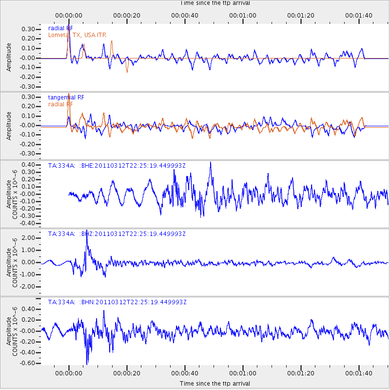
334A Lometa, TX, USA - Earthquake Result Viewer
*The percent match for this event was below the threshold and hence no stack was calculated.
| Earthquake location: |
Near East Coast Of Honshu, Japan |
| Earthquake latitude/longitude: |
37.7/141.9 |
| Earthquake time(UTC): |
2011/03/12 (071) 22:12:46 GMT |
| Earthquake Depth: |
16 km |
| Earthquake Magnitude: |
5.9 MB, 5.5 MS, 5.9 MW, 5.8 MW |
| Earthquake Catalog/Contributor: |
WHDF/NEIC |
|
| Network: |
TA USArray Transportable Network (new EarthScope stations) |
| Station: |
334A Lometa, TX, USA |
| Lat/Lon: |
31.33 N/98.24 W |
| Elevation: |
389 m |
|
| Distance: |
91.3 deg |
| Az: |
47.92 deg |
| Baz: |
316.514 deg |
| Ray Param: |
$rayparam |
*The percent match for this event was below the threshold and hence was not used in the summary stack. |
|
| Radial Match: |
76.66852 % |
| Radial Bump: |
400 |
| Transverse Match: |
74.72168 % |
| Transverse Bump: |
400 |
| SOD ConfigId: |
356183 |
| Insert Time: |
2011-08-20 08:40:14.106 +0000 |
| GWidth: |
2.5 |
| Max Bumps: |
400 |
| Tol: |
0.001 |
|
Signal To Noise
| Channel | StoN | STA | LTA |
| TA:334A: :BHZ:20110312T22:25:19.449993Z | 4.573533 | 4.355076E-7 | 9.522344E-8 |
| TA:334A: :BHN:20110312T22:25:19.449993Z | 1.3523275 | 9.9143826E-8 | 7.331348E-8 |
| TA:334A: :BHE:20110312T22:25:19.449993Z | 1.3000983 | 1.00951E-7 | 7.764875E-8 |
| Arrivals |
| Ps | |
| PpPs | |
| PsPs/PpSs | |


