You are here: Home > Network List > TA - USArray Transportable Network (new EarthScope stations) Stations List
> Station S37A Fort Scott, KS, USA > Earthquake Result Viewer
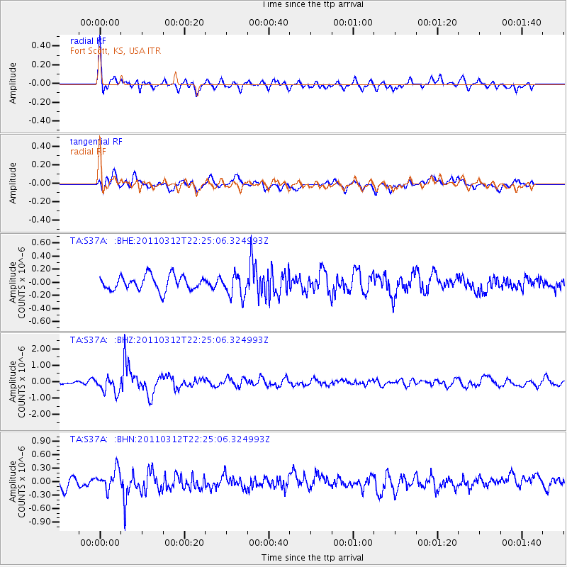
S37A Fort Scott, KS, USA - Earthquake Result Viewer
*The percent match for this event was below the threshold and hence no stack was calculated.
| Earthquake location: |
Near East Coast Of Honshu, Japan |
| Earthquake latitude/longitude: |
37.7/141.9 |
| Earthquake time(UTC): |
2011/03/12 (071) 22:12:46 GMT |
| Earthquake Depth: |
16 km |
| Earthquake Magnitude: |
5.9 MB, 5.5 MS, 5.9 MW, 5.8 MW |
| Earthquake Catalog/Contributor: |
WHDF/NEIC |
|
| Network: |
TA USArray Transportable Network (new EarthScope stations) |
| Station: |
S37A Fort Scott, KS, USA |
| Lat/Lon: |
37.76 N/94.83 W |
| Elevation: |
260 m |
|
| Distance: |
88.5 deg |
| Az: |
41.513 deg |
| Baz: |
318.433 deg |
| Ray Param: |
$rayparam |
*The percent match for this event was below the threshold and hence was not used in the summary stack. |
|
| Radial Match: |
72.7507 % |
| Radial Bump: |
400 |
| Transverse Match: |
58.91041 % |
| Transverse Bump: |
400 |
| SOD ConfigId: |
356183 |
| Insert Time: |
2011-08-20 09:04:51.037 +0000 |
| GWidth: |
2.5 |
| Max Bumps: |
400 |
| Tol: |
0.001 |
|
Signal To Noise
| Channel | StoN | STA | LTA |
| TA:S37A: :BHZ:20110312T22:25:06.324993Z | 4.6239767 | 4.875848E-7 | 1.0544707E-7 |
| TA:S37A: :BHN:20110312T22:25:06.324993Z | 2.0576258 | 2.2316367E-7 | 1.0845688E-7 |
| TA:S37A: :BHE:20110312T22:25:06.324993Z | 1.5585911 | 1.7182812E-7 | 1.102458E-7 |
| Arrivals |
| Ps | |
| PpPs | |
| PsPs/PpSs | |


