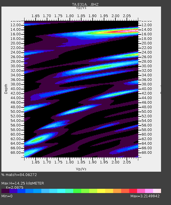
E31A Nome, ND, USA - Earthquake Result Viewer
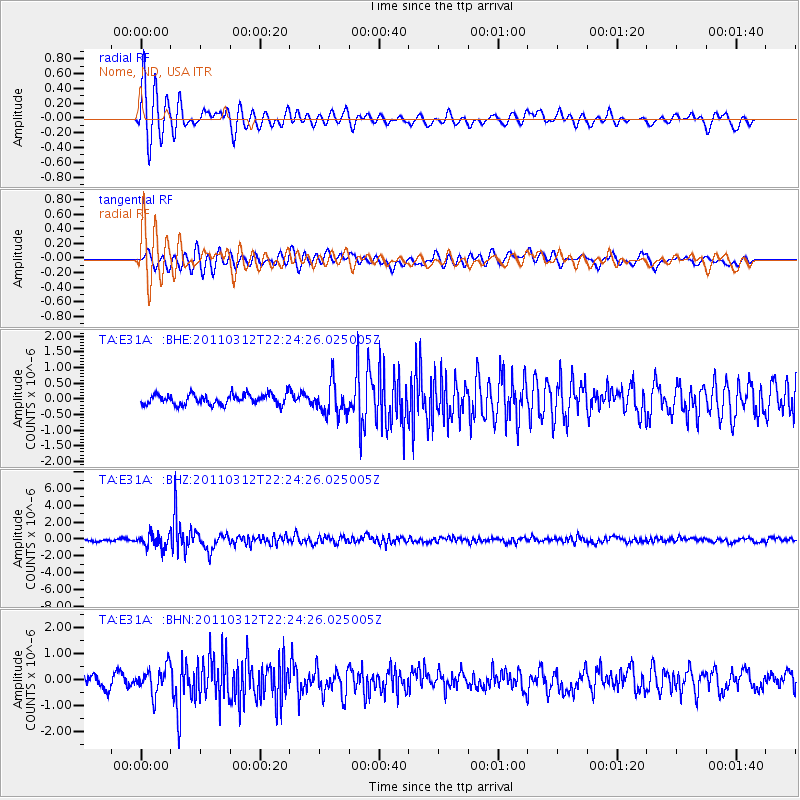
Earthquake location: Near East Coast Of Honshu, Japan
Earthquake latitude/longitude: 37.7/141.9
Earthquake time(UTC): 2011/03/12 (071) 22:12:46 GMT
Earthquake Depth: 16 km
Earthquake Magnitude: 5.9 MB, 5.5 MS, 5.9 MW, 5.8 MW
Earthquake Catalog/Contributor: WHDF/NEIC
Network: TA USArray Transportable Network (new EarthScope stations)
Station: E31A Nome, ND, USA
Lat/Lon: 46.56 N/97.89 W
Elevation: 427 m
Distance: 80.5 deg
Az: 37.195 deg
Baz: 315.966 deg
Ray Param: 0.048219744
Estimated Moho Depth: 14.25 km
Estimated Crust Vp/Vs: 2.09
Assumed Crust Vp: 6.498 km/s
Estimated Crust Vs: 3.113 km/s
Estimated Crust Poisson's Ratio: 0.35
Radial Match: 84.06272 %
Radial Bump: 400
Transverse Match: 73.16005 %
Transverse Bump: 400
SOD ConfigId: 356183
Insert Time: 2011-08-20 09:12:31.852 +0000
GWidth: 2.5
Max Bumps: 400
Tol: 0.001

Signal To Noise

ChannelStoNSTALTA
TA:E31A: :BHZ:20110312T22:24:26.025005Z5.93251048.175949E-71.3781602E-7
TA:E31A: :BHN:20110312T22:24:26.025005Z2.21831975.035392E-72.2699128E-7
TA:E31A: :BHE:20110312T22:24:26.025005Z3.01055625.021509E-71.6679672E-7
Arrivals
Ps2.4 SECOND
PpPs6.6 SECOND
PsPs/PpSs9.1 SECOND