You are here: Home > Network List > US - United States National Seismic Network Stations List
> Station DGMT Dagmar, Montana, USA > Earthquake Result Viewer
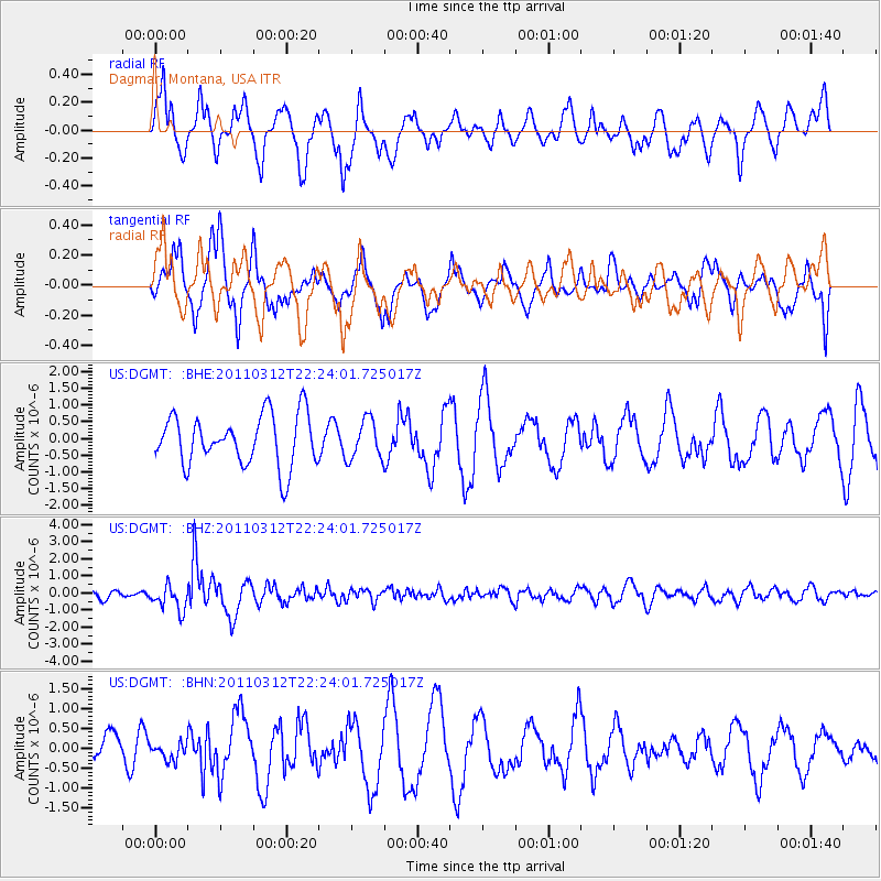
DGMT Dagmar, Montana, USA - Earthquake Result Viewer
*The percent match for this event was below the threshold and hence no stack was calculated.
| Earthquake location: |
Near East Coast Of Honshu, Japan |
| Earthquake latitude/longitude: |
37.7/141.9 |
| Earthquake time(UTC): |
2011/03/12 (071) 22:12:46 GMT |
| Earthquake Depth: |
16 km |
| Earthquake Magnitude: |
5.9 MB, 5.5 MS, 5.9 MW, 5.8 MW |
| Earthquake Catalog/Contributor: |
WHDF/NEIC |
|
| Network: |
US United States National Seismic Network |
| Station: |
DGMT Dagmar, Montana, USA |
| Lat/Lon: |
48.47 N/104.20 W |
| Elevation: |
0.0 m |
|
| Distance: |
76.1 deg |
| Az: |
38.809 deg |
| Baz: |
311.654 deg |
| Ray Param: |
$rayparam |
*The percent match for this event was below the threshold and hence was not used in the summary stack. |
|
| Radial Match: |
67.515625 % |
| Radial Bump: |
400 |
| Transverse Match: |
63.229668 % |
| Transverse Bump: |
400 |
| SOD ConfigId: |
356183 |
| Insert Time: |
2011-08-20 09:51:44.845 +0000 |
| GWidth: |
2.5 |
| Max Bumps: |
400 |
| Tol: |
0.001 |
|
Signal To Noise
| Channel | StoN | STA | LTA |
| US:DGMT: :BHZ:20110312T22:24:01.725017Z | 2.555188 | 7.2647765E-7 | 2.8431475E-7 |
| US:DGMT: :BHN:20110312T22:24:01.725017Z | 0.60673904 | 2.0281512E-7 | 3.3427077E-7 |
| US:DGMT: :BHE:20110312T22:24:01.725017Z | 0.78128725 | 5.9250664E-7 | 7.583724E-7 |
| Arrivals |
| Ps | |
| PpPs | |
| PsPs/PpSs | |


