You are here: Home > Network List > US - United States National Seismic Network Stations List
> Station GLMI Grayling, Michigan, USA > Earthquake Result Viewer
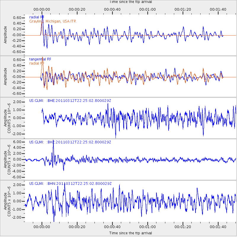
GLMI Grayling, Michigan, USA - Earthquake Result Viewer
*The percent match for this event was below the threshold and hence no stack was calculated.
| Earthquake location: |
Near East Coast Of Honshu, Japan |
| Earthquake latitude/longitude: |
37.7/141.9 |
| Earthquake time(UTC): |
2011/03/12 (071) 22:12:46 GMT |
| Earthquake Depth: |
16 km |
| Earthquake Magnitude: |
5.9 MB, 5.5 MS, 5.9 MW, 5.8 MW |
| Earthquake Catalog/Contributor: |
WHDF/NEIC |
|
| Network: |
US United States National Seismic Network |
| Station: |
GLMI Grayling, Michigan, USA |
| Lat/Lon: |
44.82 N/84.62 W |
| Elevation: |
387 m |
|
| Distance: |
87.8 deg |
| Az: |
31.108 deg |
| Baz: |
324.829 deg |
| Ray Param: |
$rayparam |
*The percent match for this event was below the threshold and hence was not used in the summary stack. |
|
| Radial Match: |
72.98437 % |
| Radial Bump: |
400 |
| Transverse Match: |
55.961212 % |
| Transverse Bump: |
400 |
| SOD ConfigId: |
356183 |
| Insert Time: |
2011-08-20 09:54:20.782 +0000 |
| GWidth: |
2.5 |
| Max Bumps: |
400 |
| Tol: |
0.001 |
|
Signal To Noise
| Channel | StoN | STA | LTA |
| US:GLMI: :BHZ:20110312T22:25:02.800029Z | 2.80435 | 7.350496E-7 | 2.6211052E-7 |
| US:GLMI: :BHN:20110312T22:25:02.800029Z | 1.9646136 | 6.757357E-7 | 3.439535E-7 |
| US:GLMI: :BHE:20110312T22:25:02.800029Z | 1.0427238 | 4.09993E-7 | 3.9319428E-7 |
| Arrivals |
| Ps | |
| PpPs | |
| PsPs/PpSs | |


