You are here: Home > Network List > IU - Global Seismograph Network (GSN - IRIS/USGS) Stations List
> Station FURI Mt. Furi, Ethiopia > Earthquake Result Viewer
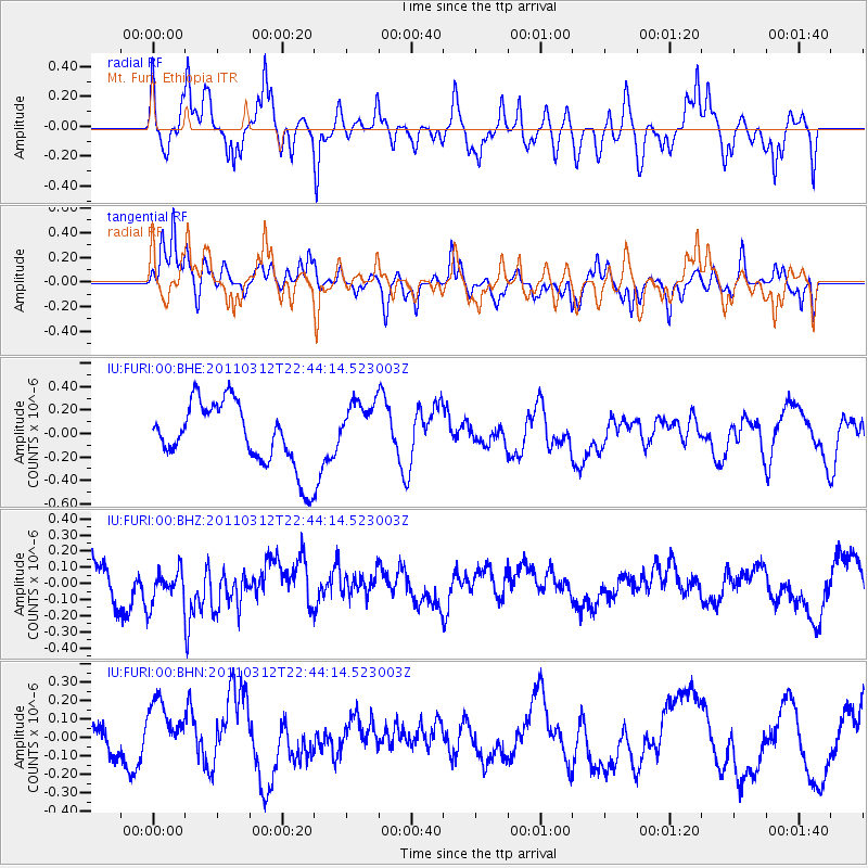
FURI Mt. Furi, Ethiopia - Earthquake Result Viewer
*The percent match for this event was below the threshold and hence no stack was calculated.
| Earthquake location: |
Near East Coast Of Honshu, Japan |
| Earthquake latitude/longitude: |
39.2/142.3 |
| Earthquake time(UTC): |
2011/03/12 (071) 22:31:27 GMT |
| Earthquake Depth: |
31 km |
| Earthquake Magnitude: |
5.5 MB, 5.3 MS, 5.3 MW |
| Earthquake Catalog/Contributor: |
WHDF/NEIC |
|
| Network: |
IU Global Seismograph Network (GSN - IRIS/USGS) |
| Station: |
FURI Mt. Furi, Ethiopia |
| Lat/Lon: |
8.90 N/38.68 E |
| Elevation: |
2570 m |
|
| Distance: |
94.8 deg |
| Az: |
285.451 deg |
| Baz: |
49.306 deg |
| Ray Param: |
$rayparam |
*The percent match for this event was below the threshold and hence was not used in the summary stack. |
|
| Radial Match: |
59.00826 % |
| Radial Bump: |
400 |
| Transverse Match: |
62.449585 % |
| Transverse Bump: |
395 |
| SOD ConfigId: |
356183 |
| Insert Time: |
2011-08-20 10:23:34.896 +0000 |
| GWidth: |
2.5 |
| Max Bumps: |
400 |
| Tol: |
0.001 |
|
Signal To Noise
| Channel | StoN | STA | LTA |
| IU:FURI:00:BHZ:20110312T22:44:14.523003Z | 1.0445079 | 1.1307703E-7 | 1.0825867E-7 |
| IU:FURI:00:BHN:20110312T22:44:14.523003Z | 0.9847836 | 1.5222783E-7 | 1.5457998E-7 |
| IU:FURI:00:BHE:20110312T22:44:14.523003Z | 0.8901956 | 2.3840913E-7 | 2.6781655E-7 |
| Arrivals |
| Ps | |
| PpPs | |
| PsPs/PpSs | |


