You are here: Home > Network List > KN - Kyrgyz Seismic Telemetry Network Stations List
> Station TKM2 KN.TKM2 > Earthquake Result Viewer
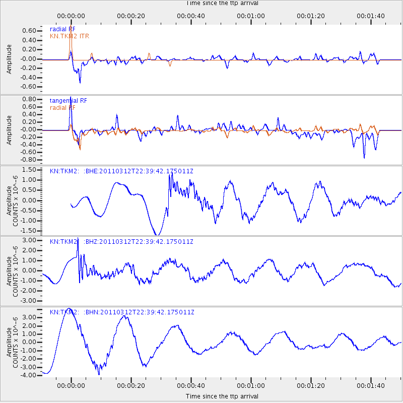
TKM2 KN.TKM2 - Earthquake Result Viewer
*The percent match for this event was below the threshold and hence no stack was calculated.
| Earthquake location: |
Near East Coast Of Honshu, Japan |
| Earthquake latitude/longitude: |
39.2/142.3 |
| Earthquake time(UTC): |
2011/03/12 (071) 22:31:27 GMT |
| Earthquake Depth: |
31 km |
| Earthquake Magnitude: |
5.5 MB, 5.3 MS, 5.3 MW |
| Earthquake Catalog/Contributor: |
WHDF/NEIC |
|
| Network: |
KN Kyrgyz Seismic Telemetry Network |
| Station: |
TKM2 KN.TKM2 |
| Lat/Lon: |
42.92 N/75.60 E |
| Elevation: |
2020 m |
|
| Distance: |
49.2 deg |
| Az: |
297.049 deg |
| Baz: |
70.461 deg |
| Ray Param: |
$rayparam |
*The percent match for this event was below the threshold and hence was not used in the summary stack. |
|
| Radial Match: |
81.18737 % |
| Radial Bump: |
400 |
| Transverse Match: |
69.713844 % |
| Transverse Bump: |
355 |
| SOD ConfigId: |
356183 |
| Insert Time: |
2011-08-20 10:27:29.514 +0000 |
| GWidth: |
2.5 |
| Max Bumps: |
400 |
| Tol: |
0.001 |
|
Signal To Noise
| Channel | StoN | STA | LTA |
| KN:TKM2: :BHZ:20110312T22:39:42.175011Z | 2.676527 | 1.4778881E-6 | 5.5216634E-7 |
| KN:TKM2: :BHN:20110312T22:39:42.175011Z | 1.4860787 | 3.240029E-6 | 2.180254E-6 |
| KN:TKM2: :BHE:20110312T22:39:42.175011Z | 2.2490997 | 1.0972981E-6 | 4.8788326E-7 |
| Arrivals |
| Ps | |
| PpPs | |
| PsPs/PpSs | |


