You are here: Home > Network List > TA - USArray Transportable Network (new EarthScope stations) Stations List
> Station D29A Pettibone, Tappen, ND, USA > Earthquake Result Viewer
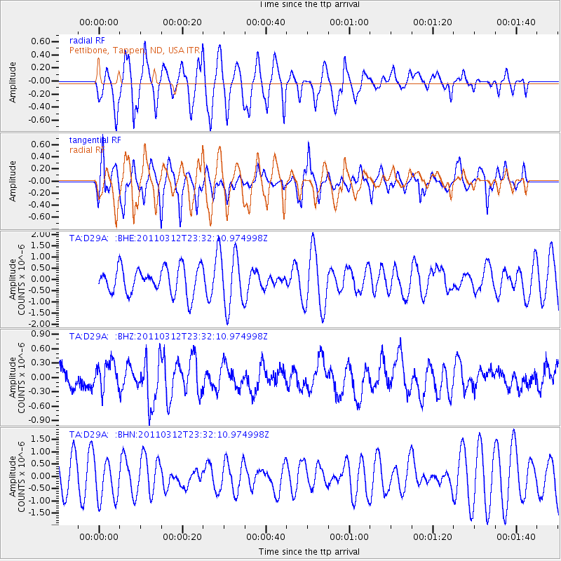
D29A Pettibone, Tappen, ND, USA - Earthquake Result Viewer
*The percent match for this event was below the threshold and hence no stack was calculated.
| Earthquake location: |
Off East Coast Of Honshu, Japan |
| Earthquake latitude/longitude: |
38.0/142.3 |
| Earthquake time(UTC): |
2011/03/12 (071) 23:20:41 GMT |
| Earthquake Depth: |
24 km |
| Earthquake Magnitude: |
5.6 MS, 5.3 MB |
| Earthquake Catalog/Contributor: |
WHDF/NEIC |
|
| Network: |
TA USArray Transportable Network (new EarthScope stations) |
| Station: |
D29A Pettibone, Tappen, ND, USA |
| Lat/Lon: |
47.06 N/99.60 W |
| Elevation: |
551 m |
|
| Distance: |
78.9 deg |
| Az: |
37.915 deg |
| Baz: |
314.758 deg |
| Ray Param: |
$rayparam |
*The percent match for this event was below the threshold and hence was not used in the summary stack. |
|
| Radial Match: |
56.435314 % |
| Radial Bump: |
388 |
| Transverse Match: |
55.34634 % |
| Transverse Bump: |
372 |
| SOD ConfigId: |
356183 |
| Insert Time: |
2011-08-20 12:17:14.706 +0000 |
| GWidth: |
2.5 |
| Max Bumps: |
400 |
| Tol: |
0.001 |
|
Signal To Noise
| Channel | StoN | STA | LTA |
| TA:D29A: :BHZ:20110312T23:32:10.974998Z | 1.552761 | 2.935796E-7 | 1.8906943E-7 |
| TA:D29A: :BHN:20110312T23:32:10.974998Z | 1.4059416 | 7.880158E-7 | 5.6048975E-7 |
| TA:D29A: :BHE:20110312T23:32:10.974998Z | 2.0041382 | 1.1885492E-6 | 5.9304745E-7 |
| Arrivals |
| Ps | |
| PpPs | |
| PsPs/PpSs | |


