You are here: Home > Network List > TA - USArray Transportable Network (new EarthScope stations) Stations List
> Station K33A Hardington, NE, USA > Earthquake Result Viewer
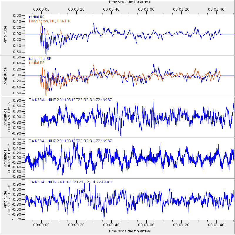
K33A Hardington, NE, USA - Earthquake Result Viewer
*The percent match for this event was below the threshold and hence no stack was calculated.
| Earthquake location: |
Off East Coast Of Honshu, Japan |
| Earthquake latitude/longitude: |
38.0/142.3 |
| Earthquake time(UTC): |
2011/03/12 (071) 23:20:41 GMT |
| Earthquake Depth: |
24 km |
| Earthquake Magnitude: |
5.6 MS, 5.3 MB |
| Earthquake Catalog/Contributor: |
WHDF/NEIC |
|
| Network: |
TA USArray Transportable Network (new EarthScope stations) |
| Station: |
K33A Hardington, NE, USA |
| Lat/Lon: |
42.61 N/97.00 W |
| Elevation: |
507 m |
|
| Distance: |
83.4 deg |
| Az: |
39.717 deg |
| Baz: |
316.861 deg |
| Ray Param: |
$rayparam |
*The percent match for this event was below the threshold and hence was not used in the summary stack. |
|
| Radial Match: |
62.517677 % |
| Radial Bump: |
400 |
| Transverse Match: |
57.316196 % |
| Transverse Bump: |
400 |
| SOD ConfigId: |
356183 |
| Insert Time: |
2011-08-20 12:26:31.641 +0000 |
| GWidth: |
2.5 |
| Max Bumps: |
400 |
| Tol: |
0.001 |
|
Signal To Noise
| Channel | StoN | STA | LTA |
| TA:K33A: :BHZ:20110312T23:32:34.724998Z | 1.0880252 | 2.5380967E-7 | 2.3327553E-7 |
| TA:K33A: :BHN:20110312T23:32:34.724998Z | 1.210085 | 2.9475547E-7 | 2.4358243E-7 |
| TA:K33A: :BHE:20110312T23:32:34.724998Z | 1.2614897 | 2.8646593E-7 | 2.2708541E-7 |
| Arrivals |
| Ps | |
| PpPs | |
| PsPs/PpSs | |


