You are here: Home > Network List > TA - USArray Transportable Network (new EarthScope stations) Stations List
> Station L37A Phoenix Point, Boone, IA, USA > Earthquake Result Viewer
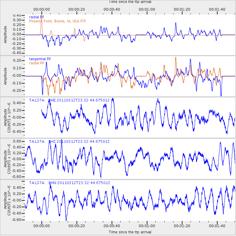
L37A Phoenix Point, Boone, IA, USA - Earthquake Result Viewer
*The percent match for this event was below the threshold and hence no stack was calculated.
| Earthquake location: |
Off East Coast Of Honshu, Japan |
| Earthquake latitude/longitude: |
38.0/142.3 |
| Earthquake time(UTC): |
2011/03/12 (071) 23:20:41 GMT |
| Earthquake Depth: |
24 km |
| Earthquake Magnitude: |
5.6 MS, 5.3 MB |
| Earthquake Catalog/Contributor: |
WHDF/NEIC |
|
| Network: |
TA USArray Transportable Network (new EarthScope stations) |
| Station: |
L37A Phoenix Point, Boone, IA, USA |
| Lat/Lon: |
42.12 N/93.75 W |
| Elevation: |
312 m |
|
| Distance: |
85.3 deg |
| Az: |
38.247 deg |
| Baz: |
318.896 deg |
| Ray Param: |
$rayparam |
*The percent match for this event was below the threshold and hence was not used in the summary stack. |
|
| Radial Match: |
57.803352 % |
| Radial Bump: |
400 |
| Transverse Match: |
53.84273 % |
| Transverse Bump: |
400 |
| SOD ConfigId: |
356183 |
| Insert Time: |
2011-08-20 12:32:10.587 +0000 |
| GWidth: |
2.5 |
| Max Bumps: |
400 |
| Tol: |
0.001 |
|
Signal To Noise
| Channel | StoN | STA | LTA |
| TA:L37A: :BHZ:20110312T23:32:44.67501Z | 0.92363787 | 3.111928E-7 | 3.3692075E-7 |
| TA:L37A: :BHN:20110312T23:32:44.67501Z | 1.7025834 | 3.1887294E-7 | 1.872877E-7 |
| TA:L37A: :BHE:20110312T23:32:44.67501Z | 1.234715 | 2.4449173E-7 | 1.9801472E-7 |
| Arrivals |
| Ps | |
| PpPs | |
| PsPs/PpSs | |


