You are here: Home > Network List > US - United States National Seismic Network Stations List
> Station ERPA Erie, Pennsylvania, USA > Earthquake Result Viewer
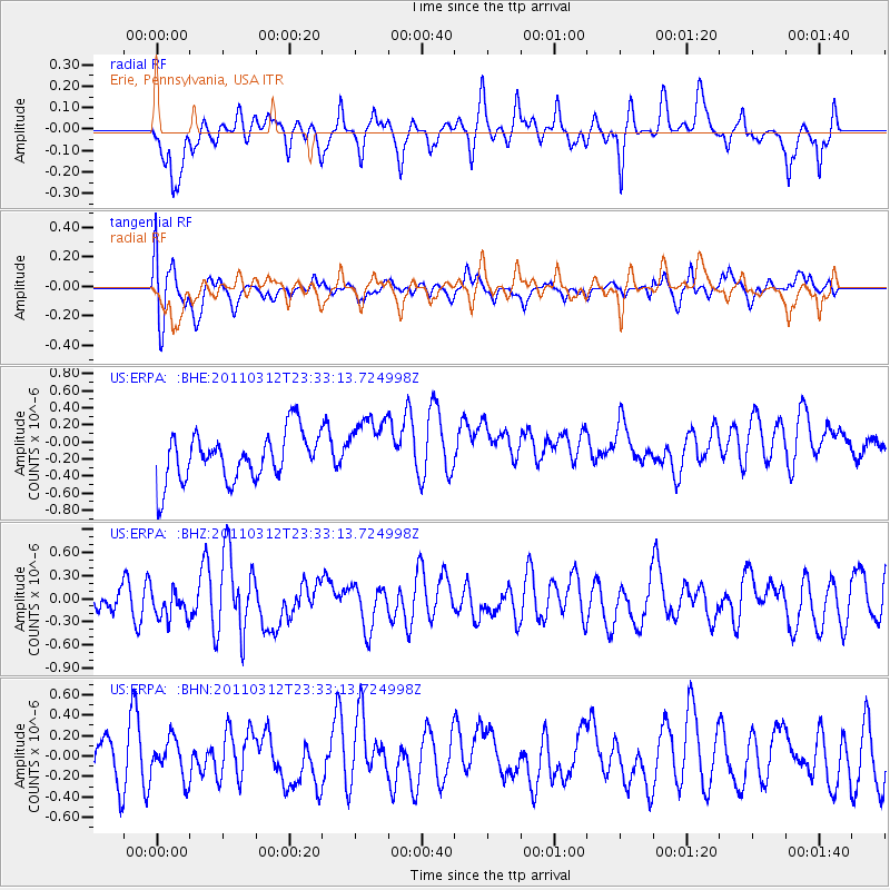
ERPA Erie, Pennsylvania, USA - Earthquake Result Viewer
*The percent match for this event was below the threshold and hence no stack was calculated.
| Earthquake location: |
Off East Coast Of Honshu, Japan |
| Earthquake latitude/longitude: |
38.0/142.3 |
| Earthquake time(UTC): |
2011/03/12 (071) 23:20:41 GMT |
| Earthquake Depth: |
24 km |
| Earthquake Magnitude: |
5.6 MS, 5.3 MB |
| Earthquake Catalog/Contributor: |
WHDF/NEIC |
|
| Network: |
US United States National Seismic Network |
| Station: |
ERPA Erie, Pennsylvania, USA |
| Lat/Lon: |
42.12 N/79.99 W |
| Elevation: |
306 m |
|
| Distance: |
91.5 deg |
| Az: |
30.04 deg |
| Baz: |
327.888 deg |
| Ray Param: |
$rayparam |
*The percent match for this event was below the threshold and hence was not used in the summary stack. |
|
| Radial Match: |
47.77845 % |
| Radial Bump: |
400 |
| Transverse Match: |
57.645023 % |
| Transverse Bump: |
400 |
| SOD ConfigId: |
356183 |
| Insert Time: |
2011-08-20 12:38:04.473 +0000 |
| GWidth: |
2.5 |
| Max Bumps: |
400 |
| Tol: |
0.001 |
|
Signal To Noise
| Channel | StoN | STA | LTA |
| US:ERPA: :BHZ:20110312T23:33:13.724998Z | 0.8981159 | 1.8596022E-7 | 2.0705593E-7 |
| US:ERPA: :BHN:20110312T23:33:13.724998Z | 0.9368851 | 1.9212601E-7 | 2.0506891E-7 |
| US:ERPA: :BHE:20110312T23:33:13.724998Z | 1.3345891 | 3.7650614E-7 | 2.821139E-7 |
| Arrivals |
| Ps | |
| PpPs | |
| PsPs/PpSs | |


