You are here: Home > Network List > CI - Caltech Regional Seismic Network Stations List
> Station MPM Manuel Prospect Mine, California, USA > Earthquake Result Viewer
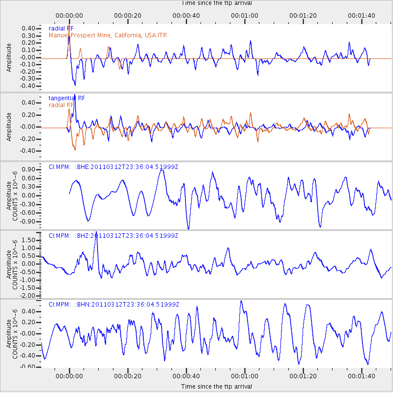
MPM Manuel Prospect Mine, California, USA - Earthquake Result Viewer
*The percent match for this event was below the threshold and hence no stack was calculated.
| Earthquake location: |
Near East Coast Of Honshu, Japan |
| Earthquake latitude/longitude: |
38.0/141.7 |
| Earthquake time(UTC): |
2011/03/12 (071) 23:24:48 GMT |
| Earthquake Depth: |
15 km |
| Earthquake Magnitude: |
6.0 MB, 5.6 MS, 6.1 MW, 5.9 MW |
| Earthquake Catalog/Contributor: |
WHDF/NEIC |
|
| Network: |
CI Caltech Regional Seismic Network |
| Station: |
MPM Manuel Prospect Mine, California, USA |
| Lat/Lon: |
36.06 N/117.49 W |
| Elevation: |
185 m |
|
| Distance: |
76.1 deg |
| Az: |
55.076 deg |
| Baz: |
306.977 deg |
| Ray Param: |
$rayparam |
*The percent match for this event was below the threshold and hence was not used in the summary stack. |
|
| Radial Match: |
67.1751 % |
| Radial Bump: |
400 |
| Transverse Match: |
81.19512 % |
| Transverse Bump: |
386 |
| SOD ConfigId: |
356183 |
| Insert Time: |
2011-08-20 12:58:11.524 +0000 |
| GWidth: |
2.5 |
| Max Bumps: |
400 |
| Tol: |
0.001 |
|
Signal To Noise
| Channel | StoN | STA | LTA |
| CI:MPM: :BHZ:20110312T23:36:04.51999Z | 1.4756131 | 5.055517E-7 | 3.4260452E-7 |
| CI:MPM: :BHN:20110312T23:36:04.51999Z | 0.5423427 | 1.06651555E-7 | 1.9664974E-7 |
| CI:MPM: :BHE:20110312T23:36:04.51999Z | 1.4533029 | 5.4898914E-7 | 3.7775274E-7 |
| Arrivals |
| Ps | |
| PpPs | |
| PsPs/PpSs | |


