P31A Stockton, KS, USA - Earthquake Result Viewer
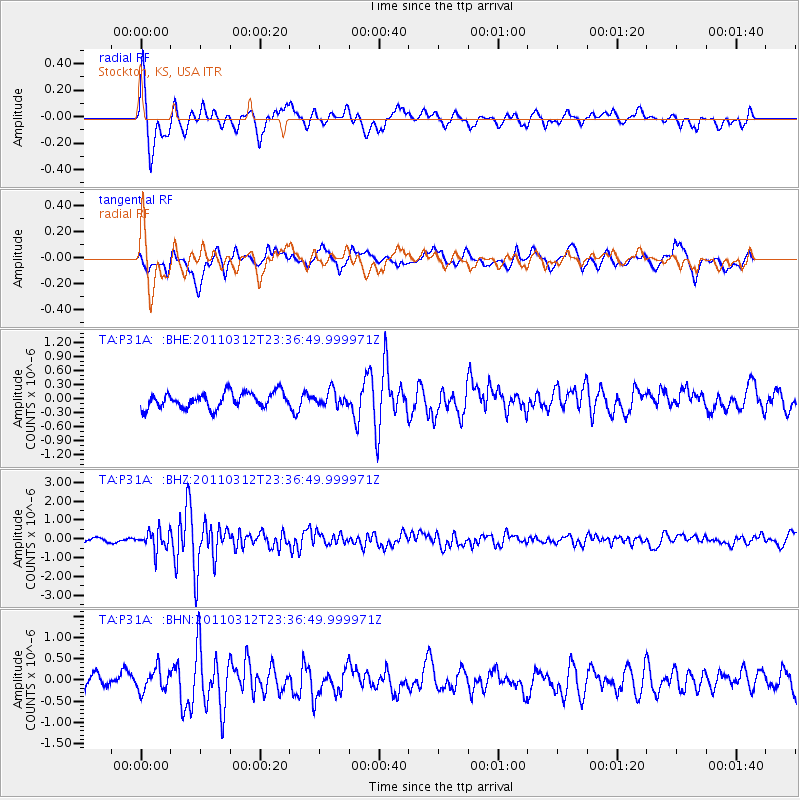
Earthquake location: Near East Coast Of Honshu, Japan
Earthquake latitude/longitude: 38.0/141.7
Earthquake time(UTC): 2011/03/12 (071) 23:24:48 GMT
Earthquake Depth: 15 km
Earthquake Magnitude: 6.0 MB, 5.6 MS, 6.1 MW, 5.9 MW
Earthquake Catalog/Contributor: WHDF/NEIC
Network: TA USArray Transportable Network (new EarthScope stations)
Station: P31A Stockton, KS, USA
Lat/Lon: 39.52 N/99.38 W
Elevation: 665 m
Distance: 84.6 deg
Az: 42.855 deg
Baz: 316.033 deg
Ray Param: 0.045347407
Estimated Moho Depth: 63.5 km
Estimated Crust Vp/Vs: 2.06
Assumed Crust Vp: 6.483 km/s
Estimated Crust Vs: 3.155 km/s
Estimated Crust Poisson's Ratio: 0.34
Radial Match: 81.230255 %
Radial Bump: 400
Transverse Match: 72.51367 %
Transverse Bump: 400
SOD ConfigId: 356183
Insert Time: 2011-08-20 13:27:57.215 +0000
GWidth: 2.5
Max Bumps: 400
Tol: 0.001

Signal To Noise

ChannelStoNSTALTA
TA:P31A: :BHZ:20110312T23:36:49.999971Z3.1017565.1235946E-71.6518368E-7
TA:P31A: :BHN:20110312T23:36:49.999971Z1.22127082.6119125E-72.1386842E-7
TA:P31A: :BHE:20110312T23:36:49.999971Z0.96395151.5832573E-71.6424656E-7
Arrivals
Ps11 SECOND
PpPs29 SECOND
PsPs/PpSs40 SECOND