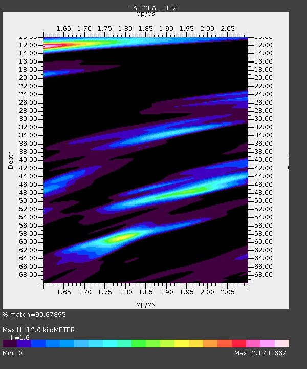
H28A Mission Ridge, SD, USA - Earthquake Result Viewer
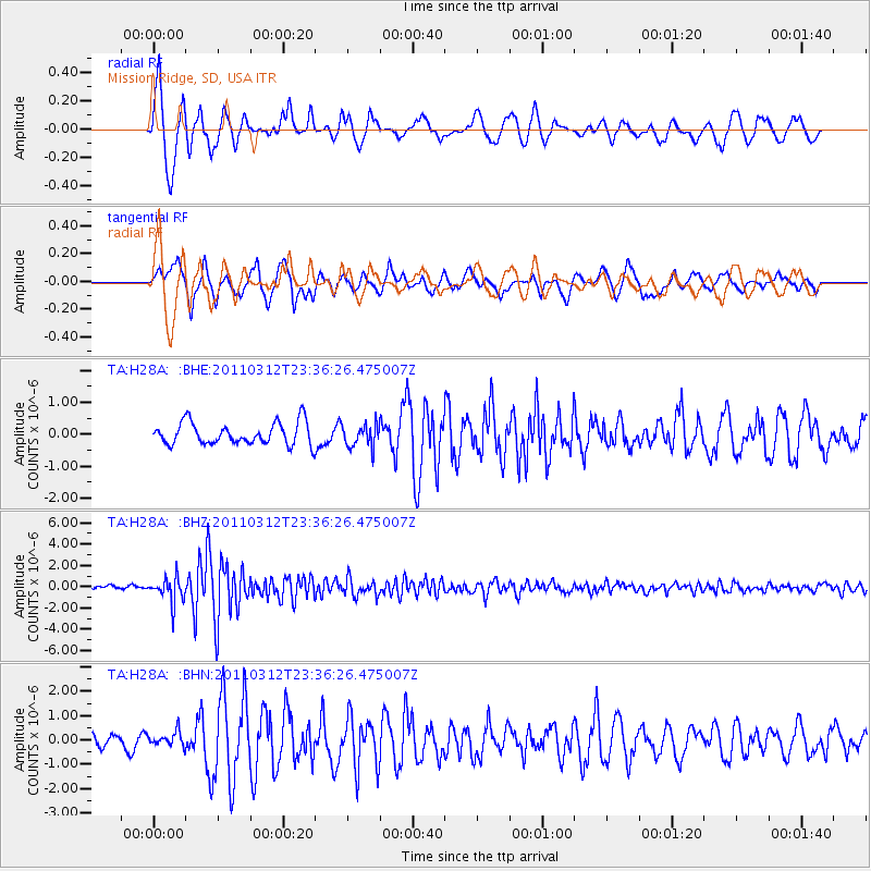
Earthquake location: Near East Coast Of Honshu, Japan
Earthquake latitude/longitude: 38.0/141.7
Earthquake time(UTC): 2011/03/12 (071) 23:24:48 GMT
Earthquake Depth: 15 km
Earthquake Magnitude: 6.0 MB, 5.6 MS, 6.1 MW, 5.9 MW
Earthquake Catalog/Contributor: WHDF/NEIC
Network: TA USArray Transportable Network (new EarthScope stations)
Station: H28A Mission Ridge, SD, USA
Lat/Lon: 44.68 N/101.02 W
Elevation: 642 m
Distance: 80.1 deg
Az: 40.078 deg
Baz: 314.565 deg
Ray Param: 0.0485032
Estimated Moho Depth: 12.0 km
Estimated Crust Vp/Vs: 1.60
Assumed Crust Vp: 6.53 km/s
Estimated Crust Vs: 4.082 km/s
Estimated Crust Poisson's Ratio: 0.18
Radial Match: 90.67895 %
Radial Bump: 383
Transverse Match: 85.11764 %
Transverse Bump: 400
SOD ConfigId: 356183
Insert Time: 2011-08-20 13:31:13.408 +0000
GWidth: 2.5
Max Bumps: 400
Tol: 0.001

Signal To Noise

ChannelStoNSTALTA
TA:H28A: :BHZ:20110312T23:36:26.475007Z5.1840141.1789061E-62.2741185E-7
TA:H28A: :BHN:20110312T23:36:26.475007Z0.933749442.9576324E-73.1674796E-7
TA:H28A: :BHE:20110312T23:36:26.475007Z1.01224113.5067558E-73.4643483E-7
Arrivals
Ps1.1 SECOND
PpPs4.6 SECOND
PsPs/PpSs5.8 SECOND