You are here: Home > Network List > TA - USArray Transportable Network (new EarthScope stations) Stations List
> Station F29A Eureka, SD, USA > Earthquake Result Viewer
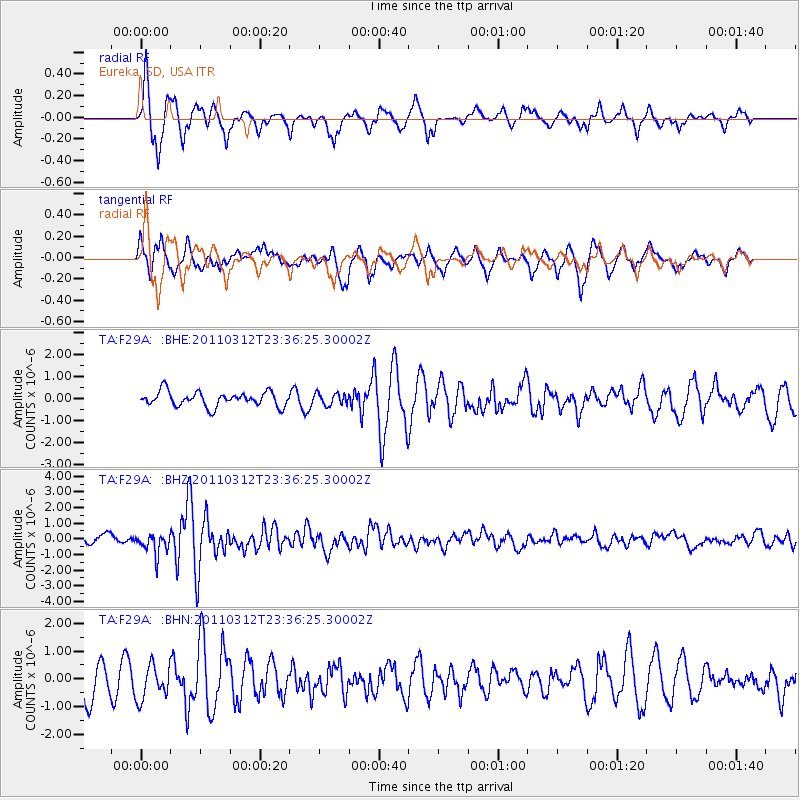
F29A Eureka, SD, USA - Earthquake Result Viewer
*The percent match for this event was below the threshold and hence no stack was calculated.
| Earthquake location: |
Near East Coast Of Honshu, Japan |
| Earthquake latitude/longitude: |
38.0/141.7 |
| Earthquake time(UTC): |
2011/03/12 (071) 23:24:48 GMT |
| Earthquake Depth: |
15 km |
| Earthquake Magnitude: |
6.0 MB, 5.6 MS, 6.1 MW, 5.9 MW |
| Earthquake Catalog/Contributor: |
WHDF/NEIC |
|
| Network: |
TA USArray Transportable Network (new EarthScope stations) |
| Station: |
F29A Eureka, SD, USA |
| Lat/Lon: |
45.83 N/99.83 W |
| Elevation: |
575 m |
|
| Distance: |
79.9 deg |
| Az: |
38.64 deg |
| Baz: |
315.16 deg |
| Ray Param: |
$rayparam |
*The percent match for this event was below the threshold and hence was not used in the summary stack. |
|
| Radial Match: |
70.57293 % |
| Radial Bump: |
385 |
| Transverse Match: |
63.365532 % |
| Transverse Bump: |
400 |
| SOD ConfigId: |
356183 |
| Insert Time: |
2011-08-20 13:43:41.888 +0000 |
| GWidth: |
2.5 |
| Max Bumps: |
400 |
| Tol: |
0.001 |
|
Signal To Noise
| Channel | StoN | STA | LTA |
| TA:F29A: :BHZ:20110312T23:36:25.30002Z | 3.1497042 | 6.7912055E-7 | 2.1561408E-7 |
| TA:F29A: :BHN:20110312T23:36:25.30002Z | 0.83010125 | 6.119689E-7 | 7.3722197E-7 |
| TA:F29A: :BHE:20110312T23:36:25.30002Z | 0.79418486 | 2.6424834E-7 | 3.32729E-7 |
| Arrivals |
| Ps | |
| PpPs | |
| PsPs/PpSs | |


