You are here: Home > Network List > TA - USArray Transportable Network (new EarthScope stations) Stations List
> Station Q35A Mercer Eighty, Eskridge, KS, USA > Earthquake Result Viewer
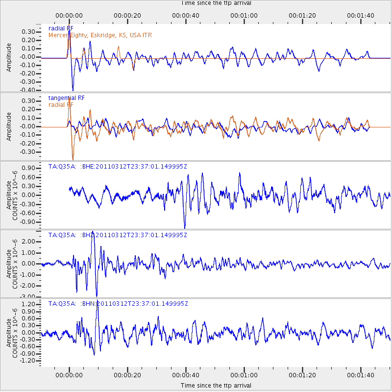
Q35A Mercer Eighty, Eskridge, KS, USA - Earthquake Result Viewer
*The percent match for this event was below the threshold and hence no stack was calculated.
| Earthquake location: |
Near East Coast Of Honshu, Japan |
| Earthquake latitude/longitude: |
38.0/141.7 |
| Earthquake time(UTC): |
2011/03/12 (071) 23:24:48 GMT |
| Earthquake Depth: |
15 km |
| Earthquake Magnitude: |
6.0 MB, 5.6 MS, 6.1 MW, 5.9 MW |
| Earthquake Catalog/Contributor: |
WHDF/NEIC |
|
| Network: |
TA USArray Transportable Network (new EarthScope stations) |
| Station: |
Q35A Mercer Eighty, Eskridge, KS, USA |
| Lat/Lon: |
38.86 N/96.04 W |
| Elevation: |
402 m |
|
| Distance: |
86.9 deg |
| Az: |
41.402 deg |
| Baz: |
318.029 deg |
| Ray Param: |
$rayparam |
*The percent match for this event was below the threshold and hence was not used in the summary stack. |
|
| Radial Match: |
73.266014 % |
| Radial Bump: |
400 |
| Transverse Match: |
68.536125 % |
| Transverse Bump: |
400 |
| SOD ConfigId: |
356183 |
| Insert Time: |
2011-08-20 14:01:04.053 +0000 |
| GWidth: |
2.5 |
| Max Bumps: |
400 |
| Tol: |
0.001 |
|
Signal To Noise
| Channel | StoN | STA | LTA |
| TA:Q35A: :BHZ:20110312T23:37:01.149995Z | 5.9203424 | 6.671519E-7 | 1.12688056E-7 |
| TA:Q35A: :BHN:20110312T23:37:01.149995Z | 1.044018 | 2.7268194E-7 | 2.6118508E-7 |
| TA:Q35A: :BHE:20110312T23:37:01.149995Z | 1.0653514 | 1.6708736E-7 | 1.568378E-7 |
| Arrivals |
| Ps | |
| PpPs | |
| PsPs/PpSs | |


