You are here: Home > Network List > TA - USArray Transportable Network (new EarthScope stations) Stations List
> Station R35A Emporia Municipal Airport, Emporia, KS, USA > Earthquake Result Viewer
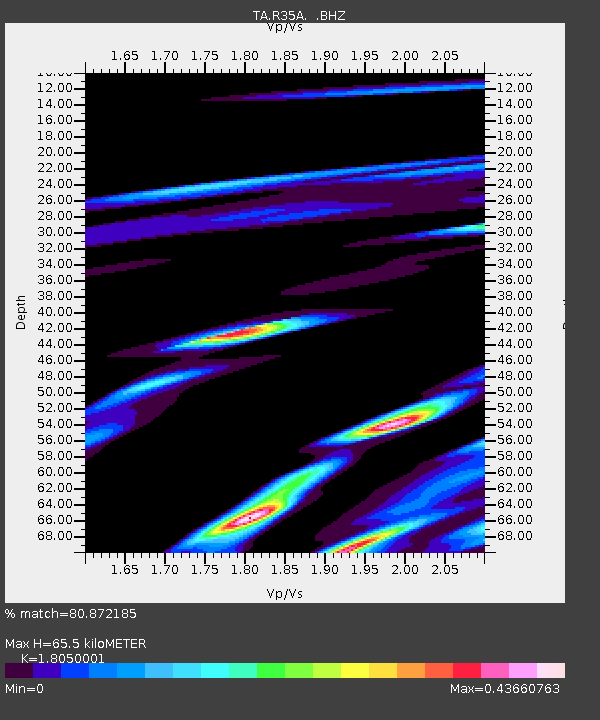
R35A Emporia Municipal Airport, Emporia, KS, USA - Earthquake Result Viewer
| Earthquake location: |
Near East Coast Of Honshu, Japan |
| Earthquake latitude/longitude: |
38.0/141.7 |
| Earthquake time(UTC): |
2011/03/12 (071) 23:24:48 GMT |
| Earthquake Depth: |
15 km |
| Earthquake Magnitude: |
6.0 MB, 5.6 MS, 6.1 MW, 5.9 MW |
| Earthquake Catalog/Contributor: |
WHDF/NEIC |
|
| Network: |
TA USArray Transportable Network (new EarthScope stations) |
| Station: |
R35A Emporia Municipal Airport, Emporia, KS, USA |
| Lat/Lon: |
38.32 N/96.20 W |
| Elevation: |
365 m |
|
| Distance: |
87.2 deg |
| Az: |
41.855 deg |
| Baz: |
317.952 deg |
| Ray Param: |
0.04350015 |
| Estimated Moho Depth: |
65.5 km |
| Estimated Crust Vp/Vs: |
1.81 |
| Assumed Crust Vp: |
6.483 km/s |
| Estimated Crust Vs: |
3.591 km/s |
| Estimated Crust Poisson's Ratio: |
0.28 |
|
| Radial Match: |
80.872185 % |
| Radial Bump: |
400 |
| Transverse Match: |
65.187874 % |
| Transverse Bump: |
400 |
| SOD ConfigId: |
356183 |
| Insert Time: |
2011-08-20 14:02:12.993 +0000 |
| GWidth: |
2.5 |
| Max Bumps: |
400 |
| Tol: |
0.001 |
|

Signal To Noise
| Channel | StoN | STA | LTA |
| TA:R35A: :BHZ:20110312T23:37:02.67502Z | 4.3153396 | 9.145259E-7 | 2.1192443E-7 |
| TA:R35A: :BHN:20110312T23:37:02.67502Z | 2.2802718 | 4.4387264E-7 | 1.9465779E-7 |
| TA:R35A: :BHE:20110312T23:37:02.67502Z | 1.0458094 | 2.8231503E-7 | 2.6994883E-7 |
| Arrivals |
| Ps | 8.3 SECOND |
| PpPs | 28 SECOND |
| PsPs/PpSs | 36 SECOND |


