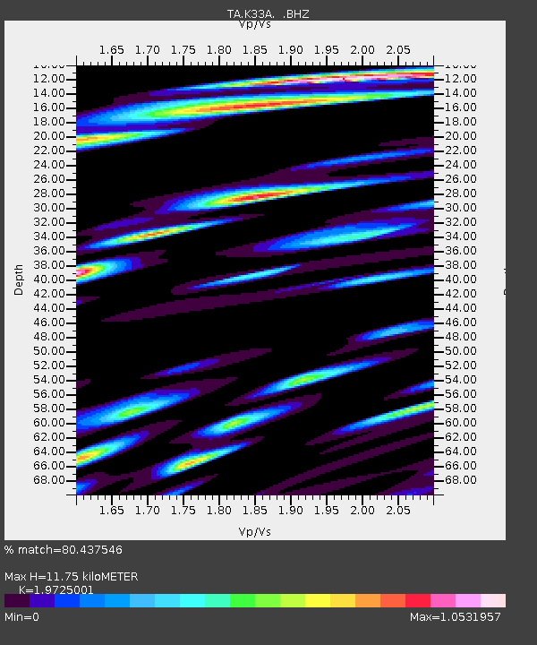
K33A Hardington, NE, USA - Earthquake Result Viewer
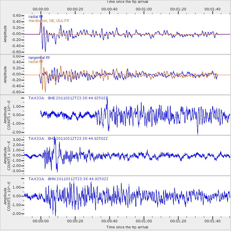
Earthquake location: Near East Coast Of Honshu, Japan
Earthquake latitude/longitude: 38.0/141.7
Earthquake time(UTC): 2011/03/12 (071) 23:24:48 GMT
Earthquake Depth: 15 km
Earthquake Magnitude: 6.0 MB, 5.6 MS, 6.1 MW, 5.9 MW
Earthquake Catalog/Contributor: WHDF/NEIC
Network: TA USArray Transportable Network (new EarthScope stations)
Station: K33A Hardington, NE, USA
Lat/Lon: 42.61 N/97.00 W
Elevation: 507 m
Distance: 83.6 deg
Az: 39.415 deg
Baz: 317.236 deg
Ray Param: 0.0460576
Estimated Moho Depth: 11.75 km
Estimated Crust Vp/Vs: 1.97
Assumed Crust Vp: 6.498 km/s
Estimated Crust Vs: 3.294 km/s
Estimated Crust Poisson's Ratio: 0.33
Radial Match: 80.437546 %
Radial Bump: 400
Transverse Match: 63.935562 %
Transverse Bump: 400
SOD ConfigId: 356183
Insert Time: 2011-08-20 14:05:36.989 +0000
GWidth: 2.5
Max Bumps: 400
Tol: 0.001

Signal To Noise

ChannelStoNSTALTA
TA:K33A: :BHZ:20110312T23:36:44.92502Z4.44013938.5008634E-71.9145489E-7
TA:K33A: :BHN:20110312T23:36:44.92502Z2.1610134.632752E-72.1437873E-7
TA:K33A: :BHE:20110312T23:36:44.92502Z1.92517084.403055E-72.2870985E-7
Arrivals
Ps1.8 SECOND
PpPs5.3 SECOND
PsPs/PpSs7.1 SECOND