You are here: Home > Network List > TA - USArray Transportable Network (new EarthScope stations) Stations List
> Station D32A Dogwood Acres, Gardner, ND, USA > Earthquake Result Viewer
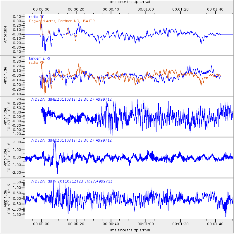
D32A Dogwood Acres, Gardner, ND, USA - Earthquake Result Viewer
*The percent match for this event was below the threshold and hence no stack was calculated.
| Earthquake location: |
Near East Coast Of Honshu, Japan |
| Earthquake latitude/longitude: |
38.0/141.7 |
| Earthquake time(UTC): |
2011/03/12 (071) 23:24:48 GMT |
| Earthquake Depth: |
15 km |
| Earthquake Magnitude: |
6.0 MB, 5.6 MS, 6.1 MW, 5.9 MW |
| Earthquake Catalog/Contributor: |
WHDF/NEIC |
|
| Network: |
TA USArray Transportable Network (new EarthScope stations) |
| Station: |
D32A Dogwood Acres, Gardner, ND, USA |
| Lat/Lon: |
47.14 N/97.02 W |
| Elevation: |
280 m |
|
| Distance: |
80.3 deg |
| Az: |
36.304 deg |
| Baz: |
316.79 deg |
| Ray Param: |
$rayparam |
*The percent match for this event was below the threshold and hence was not used in the summary stack. |
|
| Radial Match: |
51.923237 % |
| Radial Bump: |
400 |
| Transverse Match: |
52.818283 % |
| Transverse Bump: |
400 |
| SOD ConfigId: |
356183 |
| Insert Time: |
2011-08-20 14:09:02.063 +0000 |
| GWidth: |
2.5 |
| Max Bumps: |
400 |
| Tol: |
0.001 |
|
Signal To Noise
| Channel | StoN | STA | LTA |
| TA:D32A: :BHZ:20110312T23:36:27.499971Z | 1.7584906 | 3.4243365E-7 | 1.9473158E-7 |
| TA:D32A: :BHN:20110312T23:36:27.499971Z | 1.20402 | 3.0974994E-7 | 2.572631E-7 |
| TA:D32A: :BHE:20110312T23:36:27.499971Z | 1.4426885 | 3.4420168E-7 | 2.385835E-7 |
| Arrivals |
| Ps | |
| PpPs | |
| PsPs/PpSs | |


