You are here: Home > Network List > TA - USArray Transportable Network (new EarthScope stations) Stations List
> Station F31A Hecla, SD, USA > Earthquake Result Viewer
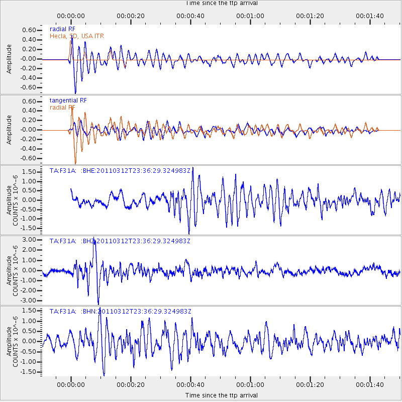
F31A Hecla, SD, USA - Earthquake Result Viewer
*The percent match for this event was below the threshold and hence no stack was calculated.
| Earthquake location: |
Near East Coast Of Honshu, Japan |
| Earthquake latitude/longitude: |
38.0/141.7 |
| Earthquake time(UTC): |
2011/03/12 (071) 23:24:48 GMT |
| Earthquake Depth: |
15 km |
| Earthquake Magnitude: |
6.0 MB, 5.6 MS, 6.1 MW, 5.9 MW |
| Earthquake Catalog/Contributor: |
WHDF/NEIC |
|
| Network: |
TA USArray Transportable Network (new EarthScope stations) |
| Station: |
F31A Hecla, SD, USA |
| Lat/Lon: |
45.86 N/98.25 W |
| Elevation: |
412 m |
|
| Distance: |
80.6 deg |
| Az: |
37.823 deg |
| Baz: |
316.148 deg |
| Ray Param: |
$rayparam |
*The percent match for this event was below the threshold and hence was not used in the summary stack. |
|
| Radial Match: |
81.361404 % |
| Radial Bump: |
400 |
| Transverse Match: |
71.10653 % |
| Transverse Bump: |
400 |
| SOD ConfigId: |
356183 |
| Insert Time: |
2011-08-20 14:11:47.818 +0000 |
| GWidth: |
2.5 |
| Max Bumps: |
400 |
| Tol: |
0.001 |
|
Signal To Noise
| Channel | StoN | STA | LTA |
| TA:F31A: :BHZ:20110312T23:36:29.324983Z | 3.0186715 | 5.3662075E-7 | 1.7776719E-7 |
| TA:F31A: :BHN:20110312T23:36:29.324983Z | 1.6554683 | 4.2934494E-7 | 2.5934952E-7 |
| TA:F31A: :BHE:20110312T23:36:29.324983Z | 1.3225853 | 3.3758016E-7 | 2.5524264E-7 |
| Arrivals |
| Ps | |
| PpPs | |
| PsPs/PpSs | |


