You are here: Home > Network List > US - United States National Seismic Network Stations List
> Station EGMT Eagleton, Montana, USA > Earthquake Result Viewer
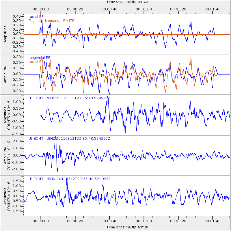
EGMT Eagleton, Montana, USA - Earthquake Result Viewer
*The percent match for this event was below the threshold and hence no stack was calculated.
| Earthquake location: |
Near East Coast Of Honshu, Japan |
| Earthquake latitude/longitude: |
38.0/141.7 |
| Earthquake time(UTC): |
2011/03/12 (071) 23:24:48 GMT |
| Earthquake Depth: |
15 km |
| Earthquake Magnitude: |
6.0 MB, 5.6 MS, 6.1 MW, 5.9 MW |
| Earthquake Catalog/Contributor: |
WHDF/NEIC |
|
| Network: |
US United States National Seismic Network |
| Station: |
EGMT Eagleton, Montana, USA |
| Lat/Lon: |
48.02 N/109.75 W |
| Elevation: |
1055 m |
|
| Distance: |
73.4 deg |
| Az: |
41.634 deg |
| Baz: |
308.615 deg |
| Ray Param: |
$rayparam |
*The percent match for this event was below the threshold and hence was not used in the summary stack. |
|
| Radial Match: |
59.973766 % |
| Radial Bump: |
400 |
| Transverse Match: |
67.4905 % |
| Transverse Bump: |
400 |
| SOD ConfigId: |
356183 |
| Insert Time: |
2011-08-20 14:27:03.644 +0000 |
| GWidth: |
2.5 |
| Max Bumps: |
400 |
| Tol: |
0.001 |
|
Signal To Noise
| Channel | StoN | STA | LTA |
| US:EGMT: :BHZ:20110312T23:35:48.524995Z | 2.4641771 | 3.725552E-7 | 1.5118847E-7 |
| US:EGMT: :BHN:20110312T23:35:48.524995Z | 0.39907655 | 1.6915475E-7 | 4.238654E-7 |
| US:EGMT: :BHE:20110312T23:35:48.524995Z | 0.90876085 | 2.3869868E-7 | 2.626639E-7 |
| Arrivals |
| Ps | |
| PpPs | |
| PsPs/PpSs | |


