You are here: Home > Network List > TA - USArray Transportable Network (new EarthScope stations) Stations List
> Station Z36A Blue Ridge, TX, USA > Earthquake Result Viewer
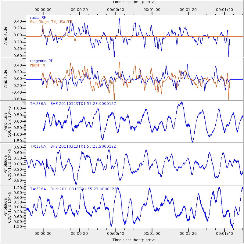
Z36A Blue Ridge, TX, USA - Earthquake Result Viewer
*The percent match for this event was below the threshold and hence no stack was calculated.
| Earthquake location: |
Off East Coast Of Honshu, Japan |
| Earthquake latitude/longitude: |
36.9/142.9 |
| Earthquake time(UTC): |
2011/03/13 (072) 01:42:51 GMT |
| Earthquake Depth: |
7.3 km |
| Earthquake Magnitude: |
5.5 MB, 5.2 MW |
| Earthquake Catalog/Contributor: |
WHDF/NEIC |
|
| Network: |
TA USArray Transportable Network (new EarthScope stations) |
| Station: |
Z36A Blue Ridge, TX, USA |
| Lat/Lon: |
33.27 N/96.43 W |
| Elevation: |
187 m |
|
| Distance: |
90.9 deg |
| Az: |
46.115 deg |
| Baz: |
316.404 deg |
| Ray Param: |
$rayparam |
*The percent match for this event was below the threshold and hence was not used in the summary stack. |
|
| Radial Match: |
61.205776 % |
| Radial Bump: |
400 |
| Transverse Match: |
60.333447 % |
| Transverse Bump: |
400 |
| SOD ConfigId: |
356183 |
| Insert Time: |
2011-08-20 15:24:12.075 +0000 |
| GWidth: |
2.5 |
| Max Bumps: |
400 |
| Tol: |
0.001 |
|
Signal To Noise
| Channel | StoN | STA | LTA |
| TA:Z36A: :BHZ:20110313T01:55:23.900012Z | 0.85716057 | 2.3152134E-7 | 2.7010267E-7 |
| TA:Z36A: :BHN:20110313T01:55:23.900012Z | 1.0395209 | 3.3102205E-7 | 3.1843715E-7 |
| TA:Z36A: :BHE:20110313T01:55:23.900012Z | 2.1923501 | 8.700077E-7 | 3.9683792E-7 |
| Arrivals |
| Ps | |
| PpPs | |
| PsPs/PpSs | |


