You are here: Home > Network List > TA - USArray Transportable Network (new EarthScope stations) Stations List
> Station M36A Felix, Anita, IA, USA > Earthquake Result Viewer
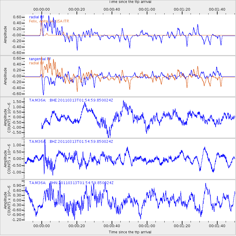
M36A Felix, Anita, IA, USA - Earthquake Result Viewer
*The percent match for this event was below the threshold and hence no stack was calculated.
| Earthquake location: |
Off East Coast Of Honshu, Japan |
| Earthquake latitude/longitude: |
36.9/142.9 |
| Earthquake time(UTC): |
2011/03/13 (072) 01:42:51 GMT |
| Earthquake Depth: |
7.3 km |
| Earthquake Magnitude: |
5.5 MB, 5.2 MW |
| Earthquake Catalog/Contributor: |
WHDF/NEIC |
|
| Network: |
TA USArray Transportable Network (new EarthScope stations) |
| Station: |
M36A Felix, Anita, IA, USA |
| Lat/Lon: |
41.45 N/94.80 W |
| Elevation: |
430 m |
|
| Distance: |
85.8 deg |
| Az: |
39.575 deg |
| Baz: |
317.208 deg |
| Ray Param: |
$rayparam |
*The percent match for this event was below the threshold and hence was not used in the summary stack. |
|
| Radial Match: |
51.623276 % |
| Radial Bump: |
400 |
| Transverse Match: |
49.58328 % |
| Transverse Bump: |
400 |
| SOD ConfigId: |
356183 |
| Insert Time: |
2011-08-20 15:30:50.933 +0000 |
| GWidth: |
2.5 |
| Max Bumps: |
400 |
| Tol: |
0.001 |
|
Signal To Noise
| Channel | StoN | STA | LTA |
| TA:M36A: :BHZ:20110313T01:54:59.850024Z | 2.4998856 | 4.475365E-7 | 1.790228E-7 |
| TA:M36A: :BHN:20110313T01:54:59.850024Z | 1.0094727 | 4.617798E-7 | 4.574465E-7 |
| TA:M36A: :BHE:20110313T01:54:59.850024Z | 1.0005141 | 4.771128E-7 | 4.768676E-7 |
| Arrivals |
| Ps | |
| PpPs | |
| PsPs/PpSs | |


