You are here: Home > Network List > TA - USArray Transportable Network (new EarthScope stations) Stations List
> Station I28A Midland, SD, USA > Earthquake Result Viewer
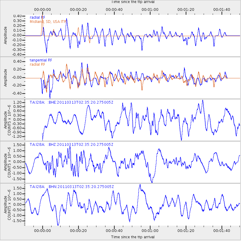
I28A Midland, SD, USA - Earthquake Result Viewer
*The percent match for this event was below the threshold and hence no stack was calculated.
| Earthquake location: |
Off East Coast Of Honshu, Japan |
| Earthquake latitude/longitude: |
36.3/142.3 |
| Earthquake time(UTC): |
2011/03/13 (072) 02:23:34 GMT |
| Earthquake Depth: |
10 km |
| Earthquake Magnitude: |
5.6 MB, 5.7 MS, 5.8 MW |
| Earthquake Catalog/Contributor: |
WHDF/NEIC |
|
| Network: |
TA USArray Transportable Network (new EarthScope stations) |
| Station: |
I28A Midland, SD, USA |
| Lat/Lon: |
44.00 N/101.17 W |
| Elevation: |
655 m |
|
| Distance: |
81.5 deg |
| Az: |
40.781 deg |
| Baz: |
313.052 deg |
| Ray Param: |
$rayparam |
*The percent match for this event was below the threshold and hence was not used in the summary stack. |
|
| Radial Match: |
67.45941 % |
| Radial Bump: |
400 |
| Transverse Match: |
70.2095 % |
| Transverse Bump: |
400 |
| SOD ConfigId: |
356183 |
| Insert Time: |
2011-08-20 15:56:54.841 +0000 |
| GWidth: |
2.5 |
| Max Bumps: |
400 |
| Tol: |
0.001 |
|
Signal To Noise
| Channel | StoN | STA | LTA |
| TA:I28A: :BHZ:20110313T02:35:20.275005Z | 0.7658663 | 4.248274E-7 | 5.547017E-7 |
| TA:I28A: :BHN:20110313T02:35:20.275005Z | 1.5557829 | 1.0255552E-6 | 6.5918914E-7 |
| TA:I28A: :BHE:20110313T02:35:20.275005Z | 1.2267884 | 5.43468E-7 | 4.430006E-7 |
| Arrivals |
| Ps | |
| PpPs | |
| PsPs/PpSs | |


