You are here: Home > Network List > TA - USArray Transportable Network (new EarthScope stations) Stations List
> Station H37A Dierke Farm, Cannon Falls, MN, USA > Earthquake Result Viewer
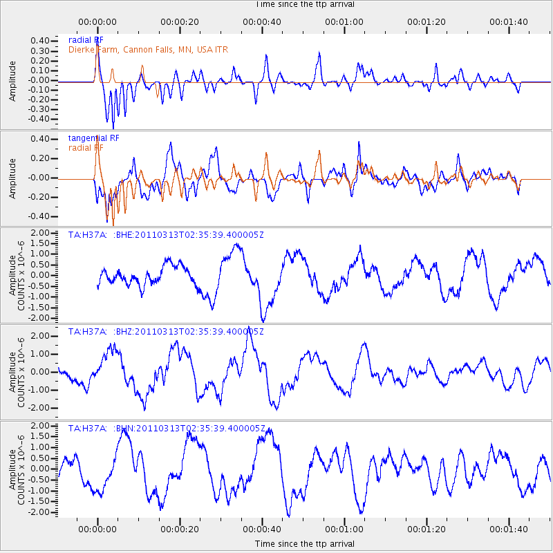
H37A Dierke Farm, Cannon Falls, MN, USA - Earthquake Result Viewer
| Earthquake location: |
Off East Coast Of Honshu, Japan |
| Earthquake latitude/longitude: |
36.3/142.3 |
| Earthquake time(UTC): |
2011/03/13 (072) 02:23:34 GMT |
| Earthquake Depth: |
10 km |
| Earthquake Magnitude: |
5.6 MB, 5.7 MS, 5.8 MW |
| Earthquake Catalog/Contributor: |
WHDF/NEIC |
|
| Network: |
TA USArray Transportable Network (new EarthScope stations) |
| Station: |
H37A Dierke Farm, Cannon Falls, MN, USA |
| Lat/Lon: |
44.58 N/92.92 W |
| Elevation: |
321 m |
|
| Distance: |
85.2 deg |
| Az: |
36.109 deg |
| Baz: |
318.255 deg |
| Ray Param: |
0.044948153 |
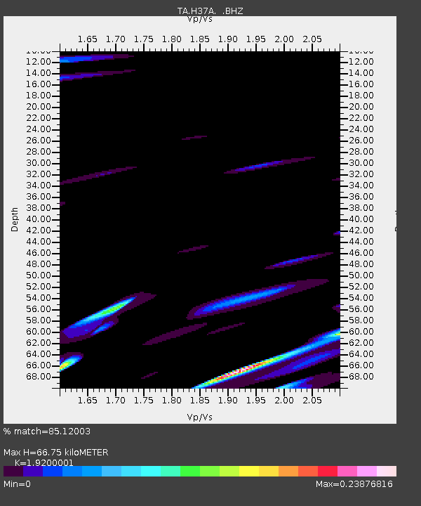
| Estimated Moho Depth: |
66.75 km |
| Estimated Crust Vp/Vs: |
1.92 |
| Assumed Crust Vp: |
6.571 km/s |
| Estimated Crust Vs: |
3.422 km/s |
| Estimated Crust Poisson's Ratio: |
0.31 |
|
| Radial Match: |
85.12003 % |
| Radial Bump: |
400 |
| Transverse Match: |
67.76397 % |
| Transverse Bump: |
400 |
| SOD ConfigId: |
356183 |
| Insert Time: |
2011-08-20 16:04:54.077 +0000 |
| GWidth: |
2.5 |
| Max Bumps: |
400 |
| Tol: |
0.001 |
|
Signal To Noise
| Channel | StoN | STA | LTA |
| TA:H37A: :BHZ:20110313T02:35:39.400005Z | 3.6077335 | 9.8604E-7 | 2.733129E-7 |
| TA:H37A: :BHN:20110313T02:35:39.400005Z | 1.503338 | 7.854211E-7 | 5.2245144E-7 |
| TA:H37A: :BHE:20110313T02:35:39.400005Z | 2.5063207 | 1.0245E-6 | 4.087665E-7 |
| Arrivals |
| Ps | 9.6 SECOND |
| PpPs | 29 SECOND |
| PsPs/PpSs | 39 SECOND |


