You are here: Home > Network List > TA - USArray Transportable Network (new EarthScope stations) Stations List
> Station K37A Belmond, IA, USA > Earthquake Result Viewer
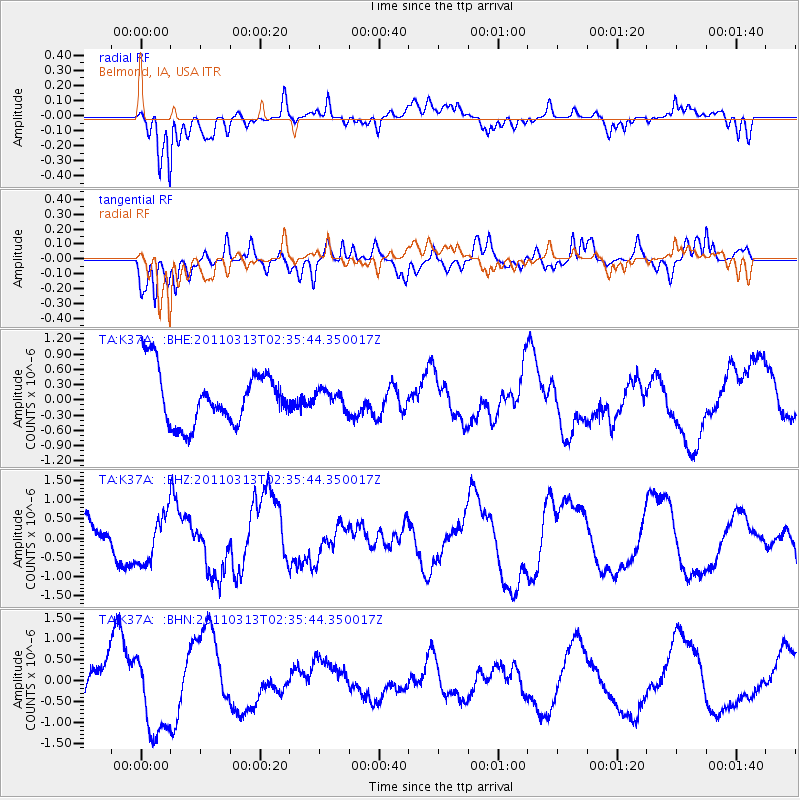
K37A Belmond, IA, USA - Earthquake Result Viewer
*The percent match for this event was below the threshold and hence no stack was calculated.
| Earthquake location: |
Off East Coast Of Honshu, Japan |
| Earthquake latitude/longitude: |
36.3/142.3 |
| Earthquake time(UTC): |
2011/03/13 (072) 02:23:34 GMT |
| Earthquake Depth: |
10 km |
| Earthquake Magnitude: |
5.6 MB, 5.7 MS, 5.8 MW |
| Earthquake Catalog/Contributor: |
WHDF/NEIC |
|
| Network: |
TA USArray Transportable Network (new EarthScope stations) |
| Station: |
K37A Belmond, IA, USA |
| Lat/Lon: |
42.77 N/93.64 W |
| Elevation: |
365 m |
|
| Distance: |
86.2 deg |
| Az: |
37.715 deg |
| Baz: |
317.88 deg |
| Ray Param: |
$rayparam |
*The percent match for this event was below the threshold and hence was not used in the summary stack. |
|
| Radial Match: |
71.99862 % |
| Radial Bump: |
400 |
| Transverse Match: |
53.928257 % |
| Transverse Bump: |
400 |
| SOD ConfigId: |
356183 |
| Insert Time: |
2011-08-20 16:05:21.717 +0000 |
| GWidth: |
2.5 |
| Max Bumps: |
400 |
| Tol: |
0.001 |
|
Signal To Noise
| Channel | StoN | STA | LTA |
| TA:K37A: :BHZ:20110313T02:35:44.350017Z | 1.6380255 | 6.3466837E-7 | 3.8745938E-7 |
| TA:K37A: :BHN:20110313T02:35:44.350017Z | 2.285258 | 9.924088E-7 | 4.342655E-7 |
| TA:K37A: :BHE:20110313T02:35:44.350017Z | 0.30219766 | 1.6074078E-7 | 5.3190615E-7 |
| Arrivals |
| Ps | |
| PpPs | |
| PsPs/PpSs | |


