You are here: Home > Network List > CI - Caltech Regional Seismic Network Stations List
> Station MPM Manuel Prospect Mine, California, USA > Earthquake Result Viewer
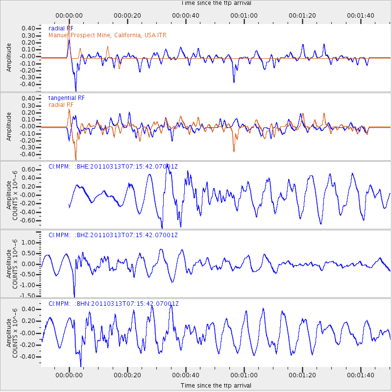
MPM Manuel Prospect Mine, California, USA - Earthquake Result Viewer
*The percent match for this event was below the threshold and hence no stack was calculated.
| Earthquake location: |
Off East Coast Of Honshu, Japan |
| Earthquake latitude/longitude: |
38.3/144.0 |
| Earthquake time(UTC): |
2011/03/13 (072) 07:04:38 GMT |
| Earthquake Depth: |
35 km |
| Earthquake Magnitude: |
5.7 MB, 5.3 MW |
| Earthquake Catalog/Contributor: |
WHDF/NEIC |
|
| Network: |
CI Caltech Regional Seismic Network |
| Station: |
MPM Manuel Prospect Mine, California, USA |
| Lat/Lon: |
36.06 N/117.49 W |
| Elevation: |
185 m |
|
| Distance: |
74.5 deg |
| Az: |
56.283 deg |
| Baz: |
306.159 deg |
| Ray Param: |
$rayparam |
*The percent match for this event was below the threshold and hence was not used in the summary stack. |
|
| Radial Match: |
60.087654 % |
| Radial Bump: |
358 |
| Transverse Match: |
78.94812 % |
| Transverse Bump: |
400 |
| SOD ConfigId: |
356183 |
| Insert Time: |
2011-08-20 16:26:27.598 +0000 |
| GWidth: |
2.5 |
| Max Bumps: |
400 |
| Tol: |
0.001 |
|
Signal To Noise
| Channel | StoN | STA | LTA |
| CI:MPM: :BHZ:20110313T07:15:42.07001Z | 1.875012 | 5.02422E-7 | 2.6795666E-7 |
| CI:MPM: :BHN:20110313T07:15:42.07001Z | 1.6824449 | 2.658377E-7 | 1.5800678E-7 |
| CI:MPM: :BHE:20110313T07:15:42.07001Z | 2.8185418 | 4.860246E-7 | 1.7243832E-7 |
| Arrivals |
| Ps | |
| PpPs | |
| PsPs/PpSs | |


