You are here: Home > Network List > IW - Intermountain West Stations List
> Station MOOW Moose Ponds, Wyoming, USA > Earthquake Result Viewer
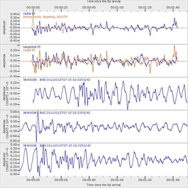
MOOW Moose Ponds, Wyoming, USA - Earthquake Result Viewer
*The percent match for this event was below the threshold and hence no stack was calculated.
| Earthquake location: |
Off East Coast Of Honshu, Japan |
| Earthquake latitude/longitude: |
38.3/144.0 |
| Earthquake time(UTC): |
2011/03/13 (072) 07:04:38 GMT |
| Earthquake Depth: |
35 km |
| Earthquake Magnitude: |
5.7 MB, 5.3 MW |
| Earthquake Catalog/Contributor: |
WHDF/NEIC |
|
| Network: |
IW Intermountain West |
| Station: |
MOOW Moose Ponds, Wyoming, USA |
| Lat/Lon: |
43.75 N/110.74 W |
| Elevation: |
2128 m |
|
| Distance: |
74.0 deg |
| Az: |
46.671 deg |
| Baz: |
307.863 deg |
| Ray Param: |
$rayparam |
*The percent match for this event was below the threshold and hence was not used in the summary stack. |
|
| Radial Match: |
65.98703 % |
| Radial Bump: |
400 |
| Transverse Match: |
54.813046 % |
| Transverse Bump: |
400 |
| SOD ConfigId: |
356183 |
| Insert Time: |
2011-08-20 16:42:00.750 +0000 |
| GWidth: |
2.5 |
| Max Bumps: |
400 |
| Tol: |
0.001 |
|
Signal To Noise
| Channel | StoN | STA | LTA |
| IW:MOOW: :BHZ:20110313T07:15:39.335024Z | 2.5221198 | 4.217647E-7 | 1.6722628E-7 |
| IW:MOOW: :BHN:20110313T07:15:39.335024Z | 1.5520341 | 2.4317453E-7 | 1.5668118E-7 |
| IW:MOOW: :BHE:20110313T07:15:39.335024Z | 1.4142845 | 1.1139135E-7 | 7.876162E-8 |
| Arrivals |
| Ps | |
| PpPs | |
| PsPs/PpSs | |


