You are here: Home > Network List > TA - USArray Transportable Network (new EarthScope stations) Stations List
> Station I25A Rochford, SD, USA > Earthquake Result Viewer
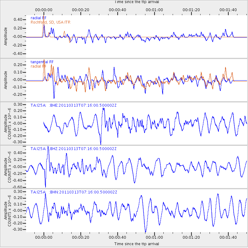
I25A Rochford, SD, USA - Earthquake Result Viewer
*The percent match for this event was below the threshold and hence no stack was calculated.
| Earthquake location: |
Off East Coast Of Honshu, Japan |
| Earthquake latitude/longitude: |
38.3/144.0 |
| Earthquake time(UTC): |
2011/03/13 (072) 07:04:38 GMT |
| Earthquake Depth: |
35 km |
| Earthquake Magnitude: |
5.7 MB, 5.3 MW |
| Earthquake Catalog/Contributor: |
WHDF/NEIC |
|
| Network: |
TA USArray Transportable Network (new EarthScope stations) |
| Station: |
I25A Rochford, SD, USA |
| Lat/Lon: |
44.02 N/103.73 W |
| Elevation: |
1856 m |
|
| Distance: |
77.7 deg |
| Az: |
43.108 deg |
| Baz: |
311.839 deg |
| Ray Param: |
$rayparam |
*The percent match for this event was below the threshold and hence was not used in the summary stack. |
|
| Radial Match: |
54.894054 % |
| Radial Bump: |
400 |
| Transverse Match: |
60.30864 % |
| Transverse Bump: |
394 |
| SOD ConfigId: |
356183 |
| Insert Time: |
2011-08-20 17:06:02.386 +0000 |
| GWidth: |
2.5 |
| Max Bumps: |
400 |
| Tol: |
0.001 |
|
Signal To Noise
| Channel | StoN | STA | LTA |
| TA:I25A: :BHZ:20110313T07:16:00.500002Z | 2.9827657 | 2.707954E-7 | 9.078668E-8 |
| TA:I25A: :BHN:20110313T07:16:00.500002Z | 1.53388 | 1.1832856E-7 | 7.71433E-8 |
| TA:I25A: :BHE:20110313T07:16:00.500002Z | 1.8880845 | 1.6330655E-7 | 8.649324E-8 |
| Arrivals |
| Ps | |
| PpPs | |
| PsPs/PpSs | |


