You are here: Home > Network List > TA - USArray Transportable Network (new EarthScope stations) Stations List
> Station C26A Wahner Farm, Parshall, ND, USA > Earthquake Result Viewer
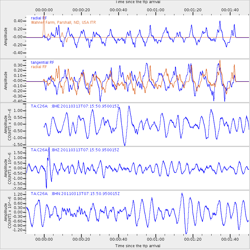
C26A Wahner Farm, Parshall, ND, USA - Earthquake Result Viewer
*The percent match for this event was below the threshold and hence no stack was calculated.
| Earthquake location: |
Off East Coast Of Honshu, Japan |
| Earthquake latitude/longitude: |
38.3/144.0 |
| Earthquake time(UTC): |
2011/03/13 (072) 07:04:38 GMT |
| Earthquake Depth: |
35 km |
| Earthquake Magnitude: |
5.7 MB, 5.3 MW |
| Earthquake Catalog/Contributor: |
WHDF/NEIC |
|
| Network: |
TA USArray Transportable Network (new EarthScope stations) |
| Station: |
C26A Wahner Farm, Parshall, ND, USA |
| Lat/Lon: |
47.83 N/102.10 W |
| Elevation: |
656 m |
|
| Distance: |
76.0 deg |
| Az: |
39.418 deg |
| Baz: |
312.172 deg |
| Ray Param: |
$rayparam |
*The percent match for this event was below the threshold and hence was not used in the summary stack. |
|
| Radial Match: |
40.129852 % |
| Radial Bump: |
400 |
| Transverse Match: |
39.81292 % |
| Transverse Bump: |
400 |
| SOD ConfigId: |
356183 |
| Insert Time: |
2011-08-20 17:13:07.357 +0000 |
| GWidth: |
2.5 |
| Max Bumps: |
400 |
| Tol: |
0.001 |
|
Signal To Noise
| Channel | StoN | STA | LTA |
| TA:C26A: :BHZ:20110313T07:15:50.950015Z | 3.310354 | 9.186569E-7 | 2.7751017E-7 |
| TA:C26A: :BHN:20110313T07:15:50.950015Z | 0.6750207 | 4.389534E-7 | 6.5028144E-7 |
| TA:C26A: :BHE:20110313T07:15:50.950015Z | 0.7442588 | 3.6183133E-7 | 4.8616334E-7 |
| Arrivals |
| Ps | |
| PpPs | |
| PsPs/PpSs | |


