You are here: Home > Network List > TA - USArray Transportable Network (new EarthScope stations) Stations List
> Station K35A Storm Lake, IA, USA > Earthquake Result Viewer
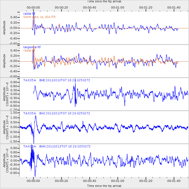
K35A Storm Lake, IA, USA - Earthquake Result Viewer
*The percent match for this event was below the threshold and hence no stack was calculated.
| Earthquake location: |
Off East Coast Of Honshu, Japan |
| Earthquake latitude/longitude: |
38.3/144.0 |
| Earthquake time(UTC): |
2011/03/13 (072) 07:04:38 GMT |
| Earthquake Depth: |
35 km |
| Earthquake Magnitude: |
5.7 MB, 5.3 MW |
| Earthquake Catalog/Contributor: |
WHDF/NEIC |
|
| Network: |
TA USArray Transportable Network (new EarthScope stations) |
| Station: |
K35A Storm Lake, IA, USA |
| Lat/Lon: |
42.72 N/95.23 W |
| Elevation: |
439 m |
|
| Distance: |
83.0 deg |
| Az: |
39.645 deg |
| Baz: |
317.081 deg |
| Ray Param: |
$rayparam |
*The percent match for this event was below the threshold and hence was not used in the summary stack. |
|
| Radial Match: |
46.60426 % |
| Radial Bump: |
400 |
| Transverse Match: |
50.02904 % |
| Transverse Bump: |
400 |
| SOD ConfigId: |
356183 |
| Insert Time: |
2011-08-20 17:59:20.241 +0000 |
| GWidth: |
2.5 |
| Max Bumps: |
400 |
| Tol: |
0.001 |
|
Signal To Noise
| Channel | StoN | STA | LTA |
| TA:K35A: :BHZ:20110313T07:16:29.025027Z | 5.1543775 | 6.7432603E-7 | 1.308259E-7 |
| TA:K35A: :BHN:20110313T07:16:29.025027Z | 2.9760113 | 4.7913693E-7 | 1.6099969E-7 |
| TA:K35A: :BHE:20110313T07:16:29.025027Z | 1.8166033 | 3.6874937E-7 | 2.0298837E-7 |
| Arrivals |
| Ps | |
| PpPs | |
| PsPs/PpSs | |


