You are here: Home > Network List > TA - USArray Transportable Network (new EarthScope stations) Stations List
> Station P37A Lathrop, MO, USA > Earthquake Result Viewer
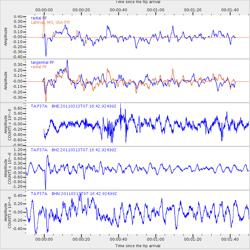
P37A Lathrop, MO, USA - Earthquake Result Viewer
*The percent match for this event was below the threshold and hence no stack was calculated.
| Earthquake location: |
Off East Coast Of Honshu, Japan |
| Earthquake latitude/longitude: |
38.3/144.0 |
| Earthquake time(UTC): |
2011/03/13 (072) 07:04:38 GMT |
| Earthquake Depth: |
35 km |
| Earthquake Magnitude: |
5.7 MB, 5.3 MW |
| Earthquake Catalog/Contributor: |
WHDF/NEIC |
|
| Network: |
TA USArray Transportable Network (new EarthScope stations) |
| Station: |
P37A Lathrop, MO, USA |
| Lat/Lon: |
39.59 N/94.35 W |
| Elevation: |
300 m |
|
| Distance: |
85.8 deg |
| Az: |
41.278 deg |
| Baz: |
317.819 deg |
| Ray Param: |
$rayparam |
*The percent match for this event was below the threshold and hence was not used in the summary stack. |
|
| Radial Match: |
36.983368 % |
| Radial Bump: |
400 |
| Transverse Match: |
38.72551 % |
| Transverse Bump: |
400 |
| SOD ConfigId: |
356183 |
| Insert Time: |
2011-08-20 18:21:57.276 +0000 |
| GWidth: |
2.5 |
| Max Bumps: |
400 |
| Tol: |
0.001 |
|
Signal To Noise
| Channel | StoN | STA | LTA |
| TA:P37A: :BHZ:20110313T07:16:42.92499Z | 3.0064495 | 4.7119997E-7 | 1.5672973E-7 |
| TA:P37A: :BHN:20110313T07:16:42.92499Z | 1.1442168 | 1.987662E-7 | 1.7371376E-7 |
| TA:P37A: :BHE:20110313T07:16:42.92499Z | 1.3843712 | 2.084045E-7 | 1.5054091E-7 |
| Arrivals |
| Ps | |
| PpPs | |
| PsPs/PpSs | |


