You are here: Home > Network List > TA - USArray Transportable Network (new EarthScope stations) Stations List
> Station P38A Dawn, MO, USA > Earthquake Result Viewer
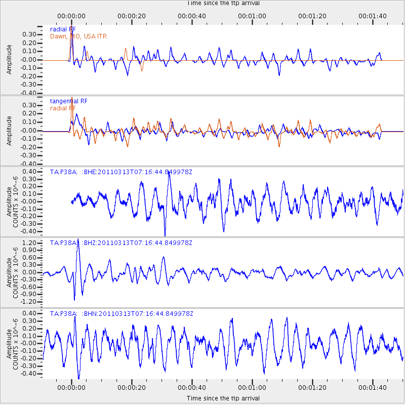
P38A Dawn, MO, USA - Earthquake Result Viewer
*The percent match for this event was below the threshold and hence no stack was calculated.
| Earthquake location: |
Off East Coast Of Honshu, Japan |
| Earthquake latitude/longitude: |
38.3/144.0 |
| Earthquake time(UTC): |
2011/03/13 (072) 07:04:38 GMT |
| Earthquake Depth: |
35 km |
| Earthquake Magnitude: |
5.7 MB, 5.3 MW |
| Earthquake Catalog/Contributor: |
WHDF/NEIC |
|
| Network: |
TA USArray Transportable Network (new EarthScope stations) |
| Station: |
P38A Dawn, MO, USA |
| Lat/Lon: |
39.62 N/93.53 W |
| Elevation: |
248 m |
|
| Distance: |
86.2 deg |
| Az: |
40.783 deg |
| Baz: |
318.304 deg |
| Ray Param: |
$rayparam |
*The percent match for this event was below the threshold and hence was not used in the summary stack. |
|
| Radial Match: |
59.71555 % |
| Radial Bump: |
321 |
| Transverse Match: |
65.719 % |
| Transverse Bump: |
400 |
| SOD ConfigId: |
356183 |
| Insert Time: |
2011-08-20 18:22:16.544 +0000 |
| GWidth: |
2.5 |
| Max Bumps: |
400 |
| Tol: |
0.001 |
|
Signal To Noise
| Channel | StoN | STA | LTA |
| TA:P38A: :BHZ:20110313T07:16:44.849978Z | 4.9933925 | 6.2398743E-7 | 1.2496263E-7 |
| TA:P38A: :BHN:20110313T07:16:44.849978Z | 2.0790725 | 2.103202E-7 | 1.0116059E-7 |
| TA:P38A: :BHE:20110313T07:16:44.849978Z | 1.9856967 | 2.0032249E-7 | 1.0088272E-7 |
| Arrivals |
| Ps | |
| PpPs | |
| PsPs/PpSs | |


