You are here: Home > Network List > US - United States National Seismic Network Stations List
> Station ERPA Erie, Pennsylvania, USA > Earthquake Result Viewer
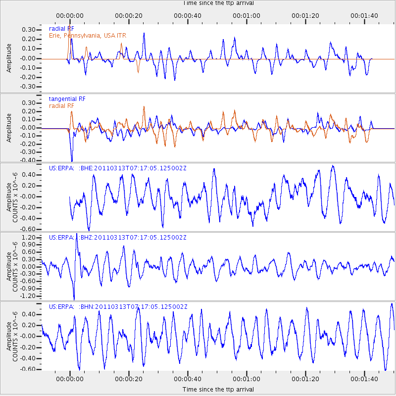
ERPA Erie, Pennsylvania, USA - Earthquake Result Viewer
*The percent match for this event was below the threshold and hence no stack was calculated.
| Earthquake location: |
Off East Coast Of Honshu, Japan |
| Earthquake latitude/longitude: |
38.3/144.0 |
| Earthquake time(UTC): |
2011/03/13 (072) 07:04:38 GMT |
| Earthquake Depth: |
35 km |
| Earthquake Magnitude: |
5.7 MB, 5.3 MW |
| Earthquake Catalog/Contributor: |
WHDF/NEIC |
|
| Network: |
US United States National Seismic Network |
| Station: |
ERPA Erie, Pennsylvania, USA |
| Lat/Lon: |
42.12 N/79.99 W |
| Elevation: |
306 m |
|
| Distance: |
90.5 deg |
| Az: |
31.126 deg |
| Baz: |
326.876 deg |
| Ray Param: |
$rayparam |
*The percent match for this event was below the threshold and hence was not used in the summary stack. |
|
| Radial Match: |
48.29921 % |
| Radial Bump: |
400 |
| Transverse Match: |
65.43117 % |
| Transverse Bump: |
400 |
| SOD ConfigId: |
356183 |
| Insert Time: |
2011-08-20 18:39:16.312 +0000 |
| GWidth: |
2.5 |
| Max Bumps: |
400 |
| Tol: |
0.001 |
|
Signal To Noise
| Channel | StoN | STA | LTA |
| US:ERPA: :BHZ:20110313T07:17:05.125002Z | 1.821862 | 6.181758E-7 | 3.3930993E-7 |
| US:ERPA: :BHN:20110313T07:17:05.125002Z | 1.2574327 | 2.7612316E-7 | 2.1959279E-7 |
| US:ERPA: :BHE:20110313T07:17:05.125002Z | 1.00296 | 2.3297387E-7 | 2.3228633E-7 |
| Arrivals |
| Ps | |
| PpPs | |
| PsPs/PpSs | |


