You are here: Home > Network List > US - United States National Seismic Network Stations List
> Station EGMT Eagleton, Montana, USA > Earthquake Result Viewer
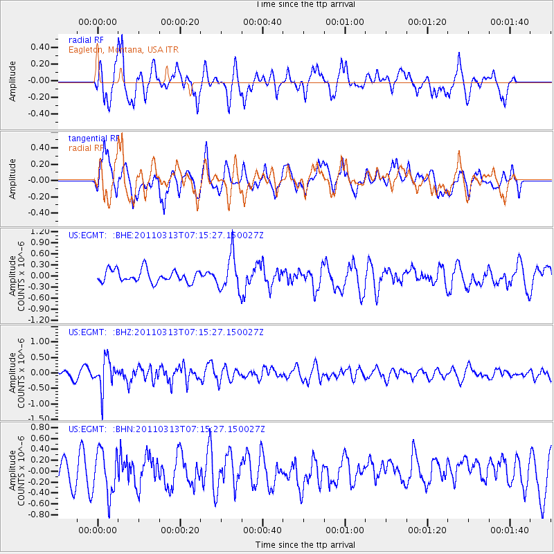
EGMT Eagleton, Montana, USA - Earthquake Result Viewer
*The percent match for this event was below the threshold and hence no stack was calculated.
| Earthquake location: |
Off East Coast Of Honshu, Japan |
| Earthquake latitude/longitude: |
38.3/144.0 |
| Earthquake time(UTC): |
2011/03/13 (072) 07:04:38 GMT |
| Earthquake Depth: |
35 km |
| Earthquake Magnitude: |
5.7 MB, 5.3 MW |
| Earthquake Catalog/Contributor: |
WHDF/NEIC |
|
| Network: |
US United States National Seismic Network |
| Station: |
EGMT Eagleton, Montana, USA |
| Lat/Lon: |
48.02 N/109.75 W |
| Elevation: |
1055 m |
|
| Distance: |
71.9 deg |
| Az: |
42.688 deg |
| Baz: |
307.404 deg |
| Ray Param: |
$rayparam |
*The percent match for this event was below the threshold and hence was not used in the summary stack. |
|
| Radial Match: |
63.09714 % |
| Radial Bump: |
400 |
| Transverse Match: |
59.050495 % |
| Transverse Bump: |
400 |
| SOD ConfigId: |
356183 |
| Insert Time: |
2011-08-20 18:41:15.138 +0000 |
| GWidth: |
2.5 |
| Max Bumps: |
400 |
| Tol: |
0.001 |
|
Signal To Noise
| Channel | StoN | STA | LTA |
| US:EGMT: :BHZ:20110313T07:15:27.150027Z | 3.9027448 | 4.9725503E-7 | 1.2741162E-7 |
| US:EGMT: :BHN:20110313T07:15:27.150027Z | 1.1148458 | 4.0715162E-7 | 3.652089E-7 |
| US:EGMT: :BHE:20110313T07:15:27.150027Z | 2.917319 | 4.933386E-7 | 1.6910681E-7 |
| Arrivals |
| Ps | |
| PpPs | |
| PsPs/PpSs | |


