You are here: Home > Network List > UW - Pacific Northwest Regional Seismic Network Stations List
> Station MRBL Marblemount, WA, USA > Earthquake Result Viewer
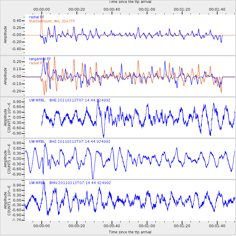
MRBL Marblemount, WA, USA - Earthquake Result Viewer
*The percent match for this event was below the threshold and hence no stack was calculated.
| Earthquake location: |
Off East Coast Of Honshu, Japan |
| Earthquake latitude/longitude: |
38.3/144.0 |
| Earthquake time(UTC): |
2011/03/13 (072) 07:04:38 GMT |
| Earthquake Depth: |
35 km |
| Earthquake Magnitude: |
5.7 MB, 5.3 MW |
| Earthquake Catalog/Contributor: |
WHDF/NEIC |
|
| Network: |
UW Pacific Northwest Regional Seismic Network |
| Station: |
MRBL Marblemount, WA, USA |
| Lat/Lon: |
48.52 N/121.48 W |
| Elevation: |
75 m |
|
| Distance: |
65.1 deg |
| Az: |
46.927 deg |
| Baz: |
300.217 deg |
| Ray Param: |
$rayparam |
*The percent match for this event was below the threshold and hence was not used in the summary stack. |
|
| Radial Match: |
55.84167 % |
| Radial Bump: |
400 |
| Transverse Match: |
45.013573 % |
| Transverse Bump: |
360 |
| SOD ConfigId: |
356183 |
| Insert Time: |
2011-08-20 18:44:37.124 +0000 |
| GWidth: |
2.5 |
| Max Bumps: |
400 |
| Tol: |
0.001 |
|
Signal To Noise
| Channel | StoN | STA | LTA |
| UW:MRBL: :BHZ:20110313T07:14:44.92499Z | 1.2448319 | 4.715917E-7 | 3.7883967E-7 |
| UW:MRBL: :BHN:20110313T07:14:44.92499Z | 2.2528677 | 6.1756305E-7 | 2.741231E-7 |
| UW:MRBL: :BHE:20110313T07:14:44.92499Z | 2.081227 | 4.9872494E-7 | 2.3963025E-7 |
| Arrivals |
| Ps | |
| PpPs | |
| PsPs/PpSs | |


