You are here: Home > Network List > ND - New CaleDonia Broadband Seismic Network Stations List
> Station KOUNC Koumac, New Caledonia > Earthquake Result Viewer
KOUNC Koumac, New Caledonia - Earthquake Result Viewer
| Earthquake location: |
Ryukyu Islands, Japan |
| Earthquake latitude/longitude: |
27.4/127.4 |
| Earthquake time(UTC): |
2014/03/02 (061) 20:11:23 GMT |
| Earthquake Depth: |
119 km |
| Earthquake Magnitude: |
6.5 MWW, 6.4 MWB, 6.5 MWC, 6.6 MI, 6.7 MI |
| Earthquake Catalog/Contributor: |
NEIC PDE/NEIC COMCAT |
|
| Network: |
ND New CaleDonia Broadband Seismic Network |
| Station: |
KOUNC Koumac, New Caledonia |
| Lat/Lon: |
20.55 S/164.29 E |
| Elevation: |
88 m |
|
| Distance: |
59.6 deg |
| Az: |
139.259 deg |
| Baz: |
321.757 deg |
| Ray Param: |
0.061728667 |
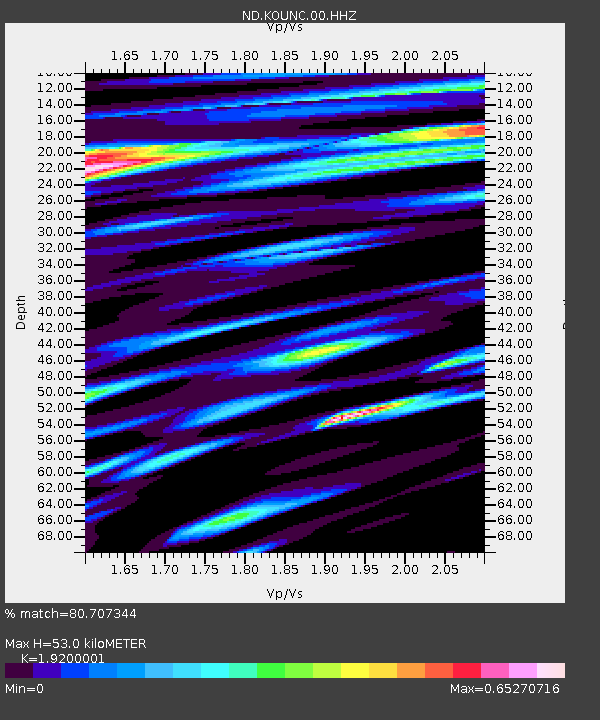
| Estimated Moho Depth: |
53.0 km |
| Estimated Crust Vp/Vs: |
1.92 |
| Assumed Crust Vp: |
5.14 km/s |
| Estimated Crust Vs: |
2.677 km/s |
| Estimated Crust Poisson's Ratio: |
0.31 |
|
| Radial Match: |
80.707344 % |
| Radial Bump: |
400 |
| Transverse Match: |
72.49587 % |
| Transverse Bump: |
400 |
| SOD ConfigId: |
3390531 |
| Insert Time: |
2019-04-10 12:03:07.336 +0000 |
| GWidth: |
2.5 |
| Max Bumps: |
400 |
| Tol: |
0.001 |
|
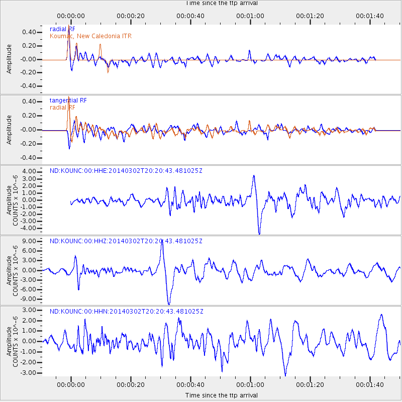
Signal To Noise
| Channel | StoN | STA | LTA |
| ND:KOUNC:00:HHZ:20140302T20:20:43.481025Z | 6.6651955 | 2.3711787E-6 | 3.557553E-7 |
| ND:KOUNC:00:HHN:20140302T20:20:43.481025Z | 3.3354933 | 8.397099E-7 | 2.5174984E-7 |
| ND:KOUNC:00:HHE:20140302T20:20:43.481025Z | 2.7503374 | 9.978384E-7 | 3.6280582E-7 |
| Arrivals |
| Ps | 9.7 SECOND |
| PpPs | 29 SECOND |
| PsPs/PpSs | 39 SECOND |


