You are here: Home > Network List > IW - Intermountain West Stations List
> Station IMW Indian Meadow, Wyoming, USA > Earthquake Result Viewer
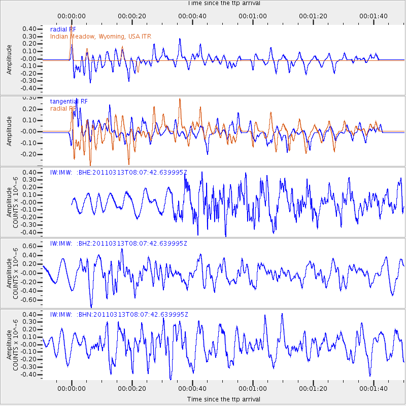
IMW Indian Meadow, Wyoming, USA - Earthquake Result Viewer
*The percent match for this event was below the threshold and hence no stack was calculated.
| Earthquake location: |
Off East Coast Of Honshu, Japan |
| Earthquake latitude/longitude: |
39.6/143.2 |
| Earthquake time(UTC): |
2011/03/13 (072) 07:56:42 GMT |
| Earthquake Depth: |
13 km |
| Earthquake Magnitude: |
5.6 MB, 5.4 MS, 5.8 MW, 5.7 MW |
| Earthquake Catalog/Contributor: |
WHDF/NEIC |
|
| Network: |
IW Intermountain West |
| Station: |
IMW Indian Meadow, Wyoming, USA |
| Lat/Lon: |
43.90 N/110.94 W |
| Elevation: |
2646 m |
|
| Distance: |
73.4 deg |
| Az: |
46.528 deg |
| Baz: |
309.183 deg |
| Ray Param: |
$rayparam |
*The percent match for this event was below the threshold and hence was not used in the summary stack. |
|
| Radial Match: |
72.800064 % |
| Radial Bump: |
400 |
| Transverse Match: |
67.329834 % |
| Transverse Bump: |
400 |
| SOD ConfigId: |
356183 |
| Insert Time: |
2011-08-20 19:07:12.484 +0000 |
| GWidth: |
2.5 |
| Max Bumps: |
400 |
| Tol: |
0.001 |
|
Signal To Noise
| Channel | StoN | STA | LTA |
| IW:IMW: :BHZ:20110313T08:07:42.639995Z | 1.834471 | 2.2637495E-7 | 1.2340067E-7 |
| IW:IMW: :BHN:20110313T08:07:42.639995Z | 0.73502314 | 1.1158059E-7 | 1.5180555E-7 |
| IW:IMW: :BHE:20110313T08:07:42.639995Z | 1.499489 | 1.482469E-7 | 9.886495E-8 |
| Arrivals |
| Ps | |
| PpPs | |
| PsPs/PpSs | |


