You are here: Home > Network List > TA - USArray Transportable Network (new EarthScope stations) Stations List
> Station A36M Sachs Harbour, NT, CAN > Earthquake Result Viewer
A36M Sachs Harbour, NT, CAN - Earthquake Result Viewer
| Earthquake location: |
Ryukyu Islands, Japan |
| Earthquake latitude/longitude: |
27.4/127.4 |
| Earthquake time(UTC): |
2014/03/02 (061) 20:11:23 GMT |
| Earthquake Depth: |
119 km |
| Earthquake Magnitude: |
6.5 MWW, 6.4 MWB, 6.5 MWC, 6.6 MI, 6.7 MI |
| Earthquake Catalog/Contributor: |
NEIC PDE/NEIC COMCAT |
|
| Network: |
TA USArray Transportable Network (new EarthScope stations) |
| Station: |
A36M Sachs Harbour, NT, CAN |
| Lat/Lon: |
71.99 N/125.25 W |
| Elevation: |
32 m |
|
| Distance: |
69.3 deg |
| Az: |
18.501 deg |
| Baz: |
294.969 deg |
| Ray Param: |
0.055402145 |
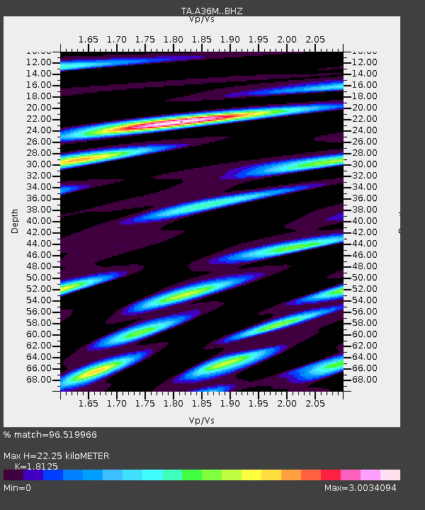
| Estimated Moho Depth: |
22.25 km |
| Estimated Crust Vp/Vs: |
1.81 |
| Assumed Crust Vp: |
6.24 km/s |
| Estimated Crust Vs: |
3.443 km/s |
| Estimated Crust Poisson's Ratio: |
0.28 |
|
| Radial Match: |
96.519966 % |
| Radial Bump: |
400 |
| Transverse Match: |
92.89941 % |
| Transverse Bump: |
400 |
| SOD ConfigId: |
3390531 |
| Insert Time: |
2019-04-10 12:03:54.891 +0000 |
| GWidth: |
2.5 |
| Max Bumps: |
400 |
| Tol: |
0.001 |
|

Signal To Noise
| Channel | StoN | STA | LTA |
| TA:A36M: :BHZ:20140302T20:21:46.648994Z | 42.349327 | 5.9190443E-6 | 1.3976714E-7 |
| TA:A36M: :BHN:20140302T20:21:46.648994Z | 12.609946 | 1.5203516E-6 | 1.2056765E-7 |
| TA:A36M: :BHE:20140302T20:21:46.648994Z | 25.984318 | 3.5201351E-6 | 1.3547152E-7 |
| Arrivals |
| Ps | 3.0 SECOND |
| PpPs | 9.7 SECOND |
| PsPs/PpSs | 13 SECOND |


