You are here: Home > Network List > TA - USArray Transportable Network (new EarthScope stations) Stations List
> Station I28A Midland, SD, USA > Earthquake Result Viewer
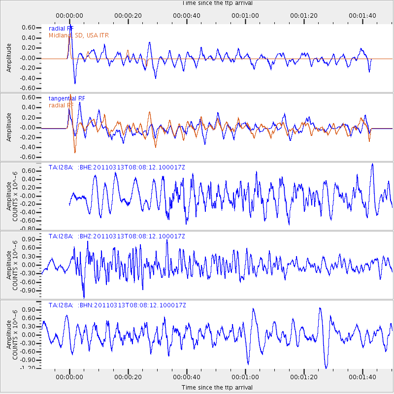
I28A Midland, SD, USA - Earthquake Result Viewer
*The percent match for this event was below the threshold and hence no stack was calculated.
| Earthquake location: |
Off East Coast Of Honshu, Japan |
| Earthquake latitude/longitude: |
39.6/143.2 |
| Earthquake time(UTC): |
2011/03/13 (072) 07:56:42 GMT |
| Earthquake Depth: |
13 km |
| Earthquake Magnitude: |
5.6 MB, 5.4 MS, 5.8 MW, 5.7 MW |
| Earthquake Catalog/Contributor: |
WHDF/NEIC |
|
| Network: |
TA USArray Transportable Network (new EarthScope stations) |
| Station: |
I28A Midland, SD, USA |
| Lat/Lon: |
44.00 N/101.17 W |
| Elevation: |
655 m |
|
| Distance: |
78.5 deg |
| Az: |
41.589 deg |
| Baz: |
314.748 deg |
| Ray Param: |
$rayparam |
*The percent match for this event was below the threshold and hence was not used in the summary stack. |
|
| Radial Match: |
68.60393 % |
| Radial Bump: |
400 |
| Transverse Match: |
59.249508 % |
| Transverse Bump: |
400 |
| SOD ConfigId: |
356183 |
| Insert Time: |
2011-08-20 19:19:51.344 +0000 |
| GWidth: |
2.5 |
| Max Bumps: |
400 |
| Tol: |
0.001 |
|
Signal To Noise
| Channel | StoN | STA | LTA |
| TA:I28A: :BHZ:20110313T08:08:12.100017Z | 2.8780007 | 3.5390275E-7 | 1.2296826E-7 |
| TA:I28A: :BHN:20110313T08:08:12.100017Z | 1.3589678 | 3.8792194E-7 | 2.8545338E-7 |
| TA:I28A: :BHE:20110313T08:08:12.100017Z | 1.2674552 | 3.188536E-7 | 2.515699E-7 |
| Arrivals |
| Ps | |
| PpPs | |
| PsPs/PpSs | |


