You are here: Home > Network List > TA - USArray Transportable Network (new EarthScope stations) Stations List
> Station E28A Huff, ND, USA > Earthquake Result Viewer
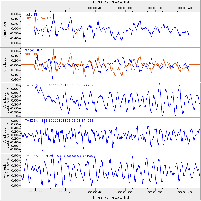
E28A Huff, ND, USA - Earthquake Result Viewer
*The percent match for this event was below the threshold and hence no stack was calculated.
| Earthquake location: |
Off East Coast Of Honshu, Japan |
| Earthquake latitude/longitude: |
39.6/143.2 |
| Earthquake time(UTC): |
2011/03/13 (072) 07:56:42 GMT |
| Earthquake Depth: |
13 km |
| Earthquake Magnitude: |
5.6 MB, 5.4 MS, 5.8 MW, 5.7 MW |
| Earthquake Catalog/Contributor: |
WHDF/NEIC |
|
| Network: |
TA USArray Transportable Network (new EarthScope stations) |
| Station: |
E28A Huff, ND, USA |
| Lat/Lon: |
46.57 N/100.69 W |
| Elevation: |
579 m |
|
| Distance: |
77.0 deg |
| Az: |
39.474 deg |
| Baz: |
314.636 deg |
| Ray Param: |
$rayparam |
*The percent match for this event was below the threshold and hence was not used in the summary stack. |
|
| Radial Match: |
62.240757 % |
| Radial Bump: |
400 |
| Transverse Match: |
51.400753 % |
| Transverse Bump: |
400 |
| SOD ConfigId: |
356183 |
| Insert Time: |
2011-08-20 19:22:52.908 +0000 |
| GWidth: |
2.5 |
| Max Bumps: |
400 |
| Tol: |
0.001 |
|
Signal To Noise
| Channel | StoN | STA | LTA |
| TA:E28A: :BHZ:20110313T08:08:03.37498Z | 1.571697 | 3.2018815E-7 | 2.0372129E-7 |
| TA:E28A: :BHN:20110313T08:08:03.37498Z | 1.0228661 | 3.6442495E-7 | 3.5627824E-7 |
| TA:E28A: :BHE:20110313T08:08:03.37498Z | 1.1416247 | 5.4616686E-7 | 4.7841195E-7 |
| Arrivals |
| Ps | |
| PpPs | |
| PsPs/PpSs | |


