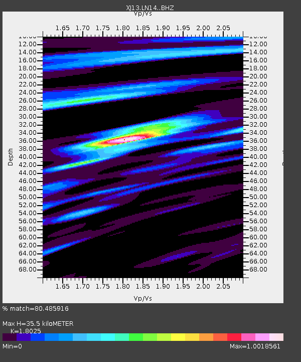
LN14 Matela PS - Earthquake Result Viewer

Earthquake location: Ryukyu Islands, Japan
Earthquake latitude/longitude: 27.4/127.4
Earthquake time(UTC): 2014/03/02 (061) 20:11:23 GMT
Earthquake Depth: 119 km
Earthquake Magnitude: 6.5 MWW, 6.4 MWB, 6.5 MWC, 6.6 MI, 6.7 MI
Earthquake Catalog/Contributor: NEIC PDE/NEIC COMCAT
Network: XJ CRAFTI
Station: LN14 Matela PS
Lat/Lon: 2.44 S/36.42 E
Elevation: 1631 m
Distance: 92.0 deg
Az: 268.282 deg
Baz: 62.775 deg
Ray Param: 0.041480485
Estimated Moho Depth: 35.5 km
Estimated Crust Vp/Vs: 1.80
Assumed Crust Vp: 6.601 km/s
Estimated Crust Vs: 3.662 km/s
Estimated Crust Poisson's Ratio: 0.28
Radial Match: 80.485916 %
Radial Bump: 400
Transverse Match: 63.603752 %
Transverse Bump: 400
SOD ConfigId: 3390531
Insert Time: 2019-04-10 12:04:33.322 +0000
GWidth: 2.5
Max Bumps: 400
Tol: 0.001

Signal To Noise

ChannelStoNSTALTA
XJ:LN14: :BHZ:20140302T20:23:46.44001Z22.8947071.7674361E-67.719846E-8
XJ:LN14: :BHN:20140302T20:23:46.44001Z4.0193542.5525333E-76.350606E-8
XJ:LN14: :BHE:20140302T20:23:46.44001Z5.6786234.3304385E-77.62586E-8
Arrivals
Ps4.4 SECOND
PpPs15 SECOND
PsPs/PpSs19 SECOND