You are here: Home > Network List > TA - USArray Transportable Network (new EarthScope stations) Stations List
> Station M31A Lambtecht Ranch, Loup City, NE, USA > Earthquake Result Viewer
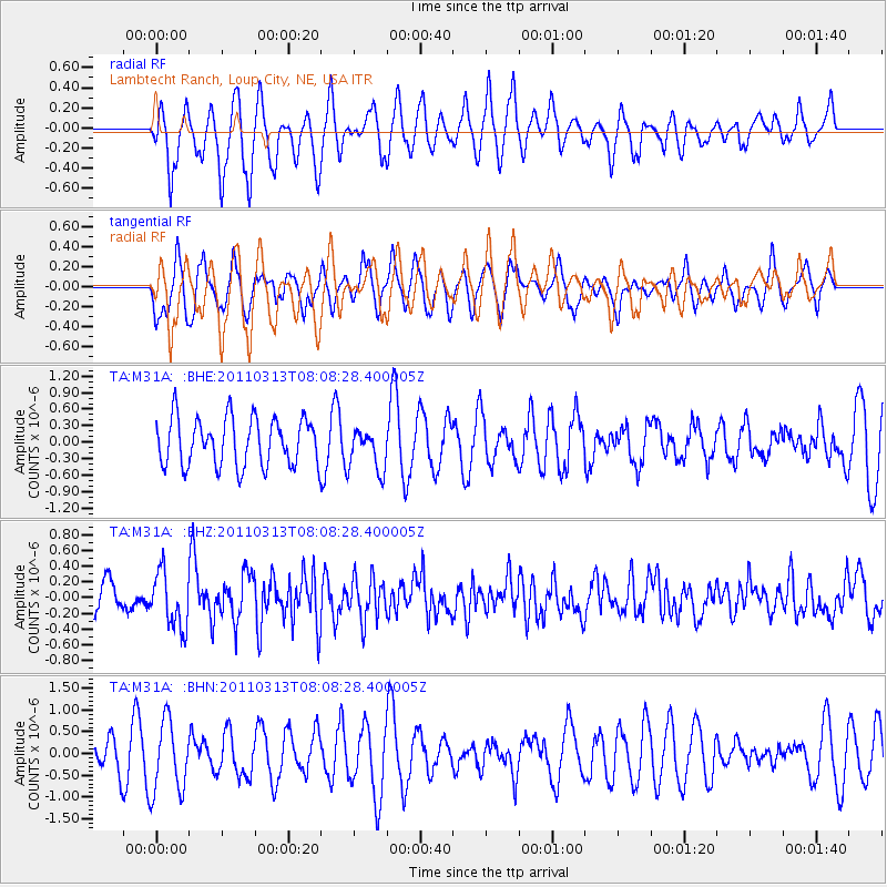
M31A Lambtecht Ranch, Loup City, NE, USA - Earthquake Result Viewer
*The percent match for this event was below the threshold and hence no stack was calculated.
| Earthquake location: |
Off East Coast Of Honshu, Japan |
| Earthquake latitude/longitude: |
39.6/143.2 |
| Earthquake time(UTC): |
2011/03/13 (072) 07:56:42 GMT |
| Earthquake Depth: |
13 km |
| Earthquake Magnitude: |
5.6 MB, 5.4 MS, 5.8 MW, 5.7 MW |
| Earthquake Catalog/Contributor: |
WHDF/NEIC |
|
| Network: |
TA USArray Transportable Network (new EarthScope stations) |
| Station: |
M31A Lambtecht Ranch, Loup City, NE, USA |
| Lat/Lon: |
41.34 N/98.98 W |
| Elevation: |
699 m |
|
| Distance: |
81.6 deg |
| Az: |
42.304 deg |
| Baz: |
316.352 deg |
| Ray Param: |
$rayparam |
*The percent match for this event was below the threshold and hence was not used in the summary stack. |
|
| Radial Match: |
62.700157 % |
| Radial Bump: |
400 |
| Transverse Match: |
64.47863 % |
| Transverse Bump: |
400 |
| SOD ConfigId: |
356183 |
| Insert Time: |
2011-08-20 19:25:04.573 +0000 |
| GWidth: |
2.5 |
| Max Bumps: |
400 |
| Tol: |
0.001 |
|
Signal To Noise
| Channel | StoN | STA | LTA |
| TA:M31A: :BHZ:20110313T08:08:28.400005Z | 2.1599464 | 3.5068726E-7 | 1.6235924E-7 |
| TA:M31A: :BHN:20110313T08:08:28.400005Z | 1.396971 | 8.2093777E-7 | 5.8765556E-7 |
| TA:M31A: :BHE:20110313T08:08:28.400005Z | 0.87463427 | 3.8188062E-7 | 4.3661748E-7 |
| Arrivals |
| Ps | |
| PpPs | |
| PsPs/PpSs | |


