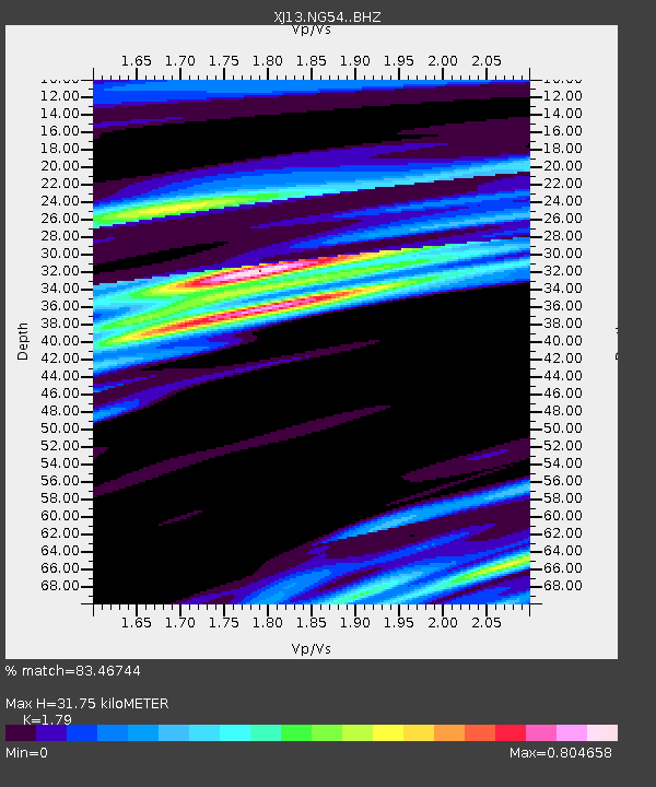
NG54 Nasera Bomas - Earthquake Result Viewer

Earthquake location: Ryukyu Islands, Japan
Earthquake latitude/longitude: 27.4/127.4
Earthquake time(UTC): 2014/03/02 (061) 20:11:23 GMT
Earthquake Depth: 119 km
Earthquake Magnitude: 6.5 MWW, 6.4 MWB, 6.5 MWC, 6.6 MI, 6.7 MI
Earthquake Catalog/Contributor: NEIC PDE/NEIC COMCAT
Network: XJ CRAFTI
Station: NG54 Nasera Bomas
Lat/Lon: 2.73 S/35.36 E
Elevation: 1853 m
Distance: 93.0 deg
Az: 268.506 deg
Baz: 62.813 deg
Ray Param: 0.041276198
Estimated Moho Depth: 31.75 km
Estimated Crust Vp/Vs: 1.79
Assumed Crust Vp: 6.576 km/s
Estimated Crust Vs: 3.674 km/s
Estimated Crust Poisson's Ratio: 0.27
Radial Match: 83.46744 %
Radial Bump: 348
Transverse Match: 65.717384 %
Transverse Bump: 400
SOD ConfigId: 3390531
Insert Time: 2019-04-10 12:04:41.266 +0000
GWidth: 2.5
Max Bumps: 400
Tol: 0.001

Signal To Noise

ChannelStoNSTALTA
XJ:NG54: :BHZ:20140302T20:23:51.359993Z27.9492781.6717885E-65.9815086E-8
XJ:NG54: :BHN:20140302T20:23:51.359993Z2.9879172.4361603E-78.1533734E-8
XJ:NG54: :BHE:20140302T20:23:51.359993Z5.16693744.6978118E-79.092062E-8
Arrivals
Ps3.9 SECOND
PpPs13 SECOND
PsPs/PpSs17 SECOND