You are here: Home > Network List > CI - Caltech Regional Seismic Network Stations List
> Station BAR Barrett, Tecate, CA, USA > Earthquake Result Viewer
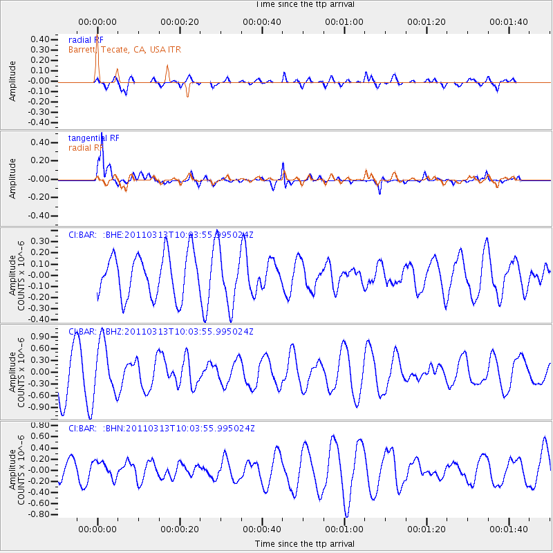
BAR Barrett, Tecate, CA, USA - Earthquake Result Viewer
*The percent match for this event was below the threshold and hence no stack was calculated.
| Earthquake location: |
Near East Coast Of Honshu, Japan |
| Earthquake latitude/longitude: |
38.8/141.9 |
| Earthquake time(UTC): |
2011/03/13 (072) 09:52:30 GMT |
| Earthquake Depth: |
33 km |
| Earthquake Magnitude: |
5.6 MW, 5.0 MS, 5.4 MB, 5.6 MW |
| Earthquake Catalog/Contributor: |
WHDF/NEIC |
|
| Network: |
CI Caltech Regional Seismic Network |
| Station: |
BAR Barrett, Tecate, CA, USA |
| Lat/Lon: |
32.68 N/116.67 W |
| Elevation: |
521 m |
|
| Distance: |
78.2 deg |
| Az: |
57.607 deg |
| Baz: |
308.572 deg |
| Ray Param: |
$rayparam |
*The percent match for this event was below the threshold and hence was not used in the summary stack. |
|
| Radial Match: |
58.2496 % |
| Radial Bump: |
400 |
| Transverse Match: |
86.96373 % |
| Transverse Bump: |
391 |
| SOD ConfigId: |
356183 |
| Insert Time: |
2011-08-20 19:54:25.430 +0000 |
| GWidth: |
2.5 |
| Max Bumps: |
400 |
| Tol: |
0.001 |
|
Signal To Noise
| Channel | StoN | STA | LTA |
| CI:BAR: :BHZ:20110313T10:03:55.995024Z | 1.3104599 | 6.4391276E-7 | 4.91364E-7 |
| CI:BAR: :BHN:20110313T10:03:55.995024Z | 0.8033714 | 1.4849691E-7 | 1.8484215E-7 |
| CI:BAR: :BHE:20110313T10:03:55.995024Z | 1.3037411 | 2.492715E-7 | 1.9119709E-7 |
| Arrivals |
| Ps | |
| PpPs | |
| PsPs/PpSs | |


