You are here: Home > Network List > XL12 - Hangay Dome, Mongolia Stations List
> Station HD38 HD38 > Earthquake Result Viewer
HD38 HD38 - Earthquake Result Viewer
| Earthquake location: |
Ryukyu Islands, Japan |
| Earthquake latitude/longitude: |
27.4/127.4 |
| Earthquake time(UTC): |
2014/03/02 (061) 20:11:23 GMT |
| Earthquake Depth: |
119 km |
| Earthquake Magnitude: |
6.5 MWW, 6.4 MWB, 6.5 MWC, 6.6 MI, 6.7 MI |
| Earthquake Catalog/Contributor: |
NEIC PDE/NEIC COMCAT |
|
| Network: |
XL Hangay Dome, Mongolia |
| Station: |
HD38 HD38 |
| Lat/Lon: |
48.09 N/98.87 E |
| Elevation: |
2253 m |
|
| Distance: |
30.3 deg |
| Az: |
320.602 deg |
| Baz: |
122.706 deg |
| Ray Param: |
0.07917398 |
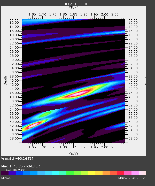
| Estimated Moho Depth: |
46.25 km |
| Estimated Crust Vp/Vs: |
1.87 |
| Assumed Crust Vp: |
6.642 km/s |
| Estimated Crust Vs: |
3.557 km/s |
| Estimated Crust Poisson's Ratio: |
0.30 |
|
| Radial Match: |
90.16454 % |
| Radial Bump: |
223 |
| Transverse Match: |
58.559174 % |
| Transverse Bump: |
400 |
| SOD ConfigId: |
3390531 |
| Insert Time: |
2019-04-10 12:05:01.279 +0000 |
| GWidth: |
2.5 |
| Max Bumps: |
400 |
| Tol: |
0.001 |
|

Signal To Noise
| Channel | StoN | STA | LTA |
| XL:HD38: :HHZ:20140302T20:16:52.120002Z | 31.243626 | 3.8865546E-6 | 1.2439511E-7 |
| XL:HD38: :HHN:20140302T20:16:52.120002Z | 15.195216 | 1.2570184E-6 | 8.272461E-8 |
| XL:HD38: :HHE:20140302T20:16:52.120002Z | 32.96083 | 1.9308538E-6 | 5.8580255E-8 |
| Arrivals |
| Ps | 6.6 SECOND |
| PpPs | 18 SECOND |
| PsPs/PpSs | 25 SECOND |


