You are here: Home > Network List > YB13 - Continental Dynamics/Cent. Anatolian Tectonics:Surface to Mantle Dynamics During Stations List
> Station AT05 Ormanici,Malatya,Turkey > Earthquake Result Viewer
AT05 Ormanici,Malatya,Turkey - Earthquake Result Viewer
| Earthquake location: |
Ryukyu Islands, Japan |
| Earthquake latitude/longitude: |
27.4/127.4 |
| Earthquake time(UTC): |
2014/03/02 (061) 20:11:23 GMT |
| Earthquake Depth: |
119 km |
| Earthquake Magnitude: |
6.5 MWW, 6.4 MWB, 6.5 MWC, 6.6 MI, 6.7 MI |
| Earthquake Catalog/Contributor: |
NEIC PDE/NEIC COMCAT |
|
| Network: |
YB Continental Dynamics/Cent. Anatolian Tectonics:Surface to Mantle Dynamics During |
| Station: |
AT05 Ormanici,Malatya,Turkey |
| Lat/Lon: |
38.22 N/38.79 E |
| Elevation: |
851 m |
|
| Distance: |
72.6 deg |
| Az: |
304.372 deg |
| Baz: |
68.65 deg |
| Ray Param: |
0.05328797 |
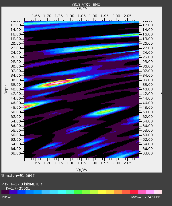
| Estimated Moho Depth: |
37.0 km |
| Estimated Crust Vp/Vs: |
1.74 |
| Assumed Crust Vp: |
6.35 km/s |
| Estimated Crust Vs: |
3.644 km/s |
| Estimated Crust Poisson's Ratio: |
0.25 |
|
| Radial Match: |
91.5667 % |
| Radial Bump: |
400 |
| Transverse Match: |
86.34878 % |
| Transverse Bump: |
400 |
| SOD ConfigId: |
3390531 |
| Insert Time: |
2019-04-10 12:05:15.858 +0000 |
| GWidth: |
2.5 |
| Max Bumps: |
400 |
| Tol: |
0.001 |
|

Signal To Noise
| Channel | StoN | STA | LTA |
| YB:AT05: :BHZ:20140302T20:22:05.799995Z | 43.80391 | 4.878752E-6 | 1.113771E-7 |
| YB:AT05: :BHN:20140302T20:22:05.799995Z | 20.32393 | 1.0731809E-6 | 5.2803802E-8 |
| YB:AT05: :BHE:20140302T20:22:05.799995Z | 18.044235 | 1.7205526E-6 | 9.5351936E-8 |
| Arrivals |
| Ps | 4.5 SECOND |
| PpPs | 15 SECOND |
| PsPs/PpSs | 20 SECOND |


