You are here: Home > Network List > TA - USArray Transportable Network (new EarthScope stations) Stations List
> Station D28A Regan, ND, USA > Earthquake Result Viewer
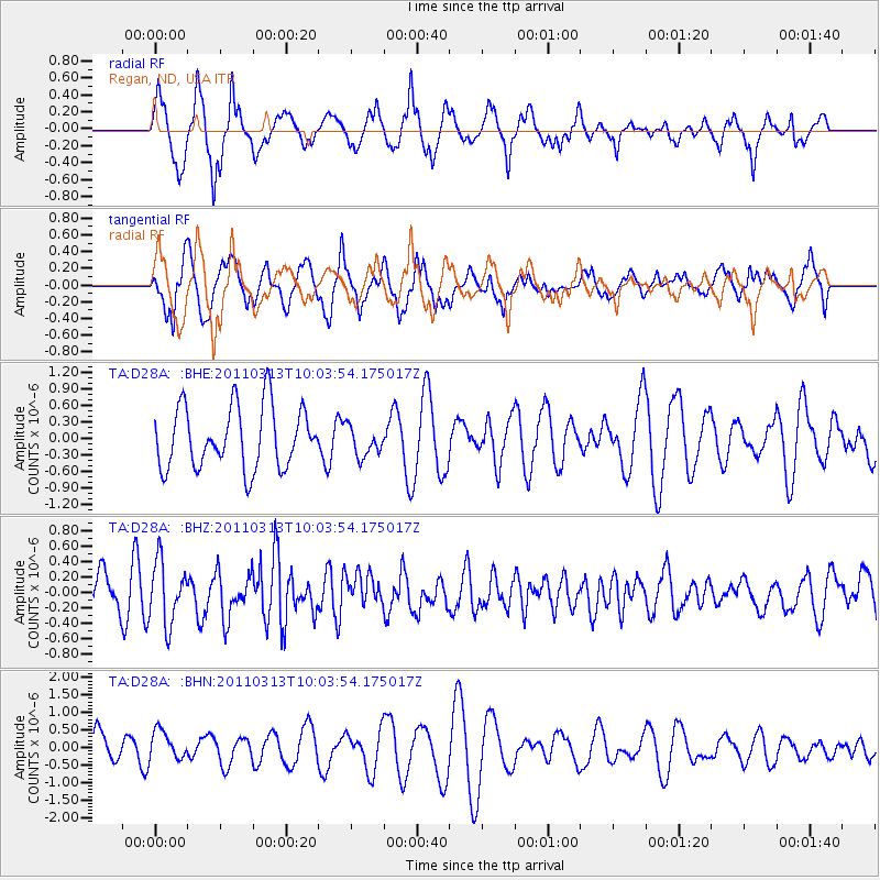
D28A Regan, ND, USA - Earthquake Result Viewer
*The percent match for this event was below the threshold and hence no stack was calculated.
| Earthquake location: |
Near East Coast Of Honshu, Japan |
| Earthquake latitude/longitude: |
38.8/141.9 |
| Earthquake time(UTC): |
2011/03/13 (072) 09:52:30 GMT |
| Earthquake Depth: |
33 km |
| Earthquake Magnitude: |
5.6 MW, 5.0 MS, 5.4 MB, 5.6 MW |
| Earthquake Catalog/Contributor: |
WHDF/NEIC |
|
| Network: |
TA USArray Transportable Network (new EarthScope stations) |
| Station: |
D28A Regan, ND, USA |
| Lat/Lon: |
47.19 N/100.57 W |
| Elevation: |
621 m |
|
| Distance: |
77.9 deg |
| Az: |
38.197 deg |
| Baz: |
314.926 deg |
| Ray Param: |
$rayparam |
*The percent match for this event was below the threshold and hence was not used in the summary stack. |
|
| Radial Match: |
50.214005 % |
| Radial Bump: |
376 |
| Transverse Match: |
72.18431 % |
| Transverse Bump: |
400 |
| SOD ConfigId: |
356183 |
| Insert Time: |
2011-08-20 20:18:07.979 +0000 |
| GWidth: |
2.5 |
| Max Bumps: |
400 |
| Tol: |
0.001 |
|
Signal To Noise
| Channel | StoN | STA | LTA |
| TA:D28A: :BHZ:20110313T10:03:54.175017Z | 2.4125795 | 3.9959443E-7 | 1.6562953E-7 |
| TA:D28A: :BHN:20110313T10:03:54.175017Z | 0.8226817 | 4.3545828E-7 | 5.293156E-7 |
| TA:D28A: :BHE:20110313T10:03:54.175017Z | 0.47989908 | 2.6918318E-7 | 5.6091625E-7 |
| Arrivals |
| Ps | |
| PpPs | |
| PsPs/PpSs | |


